|
||

|

|
|

|
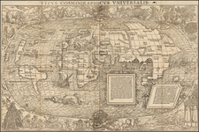
Rare separately issued World Map by chez Jean in the 8th Year of the French Republic (Ans. 8).
Jean's map, based upon earlier maps by J.B. Nolin, shows both the Bay of the West and the River of the West, one of the latest maps to illustrate this cartographic myth. An area on the northwest coast is labelled "Fou-san des Chinois," recognition of the belief that the Chinese may have reached the West Coast of America prior to Columbus. The route of a Russian expedition in 1709 is shown, are the routes of Cook, Tasman, Fourneaux, Magellan, Mendana, Quiros, Bouganville, Drake, Edmund Hally and others.
The cartographic anomally presented in this map is striking, given that it is dated (1800) and the United States are shown, and yet several fantastic myths of the mid-18th Century still appear onthe map. The map is surrounded by models of the Universe, including those by Descartes, Copernicus, Tycho Brahe and Ptolemy.
We can track editions of the map as early as circa 1740 and Jean seems to have issued a variant edition of the map with teh same title but lacking the decorative cartouche as late as 1820.
A rare separately issued example with original covers, in nearly flawless condition.
![Great Overland Route! Chicago Rock Island and Pacific RR for California, Oregon Australia, China and Japan. [Cover title.]](https://storage.googleapis.com/raremaps/img/small/72924.jpg)