


|
||

|

|
|

|
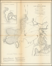
Derby's map of the San Diego River is the earliest obtainable map of San Diego to show Mission Valley and the San Diego River with any significant detail.
Mission Valley was known to the Spanish as La Canada de San Diego. The first mention of the San Diego River was in the diary of explorer Sebastian Vizcaino. In 1602, Vizcaino left San Diego Bay to investigate what he called False Bay (now Mission Bay), noting that it was a "good port, although it had at its entrance a bar of little more than 2 fathoms depth, and there was a very large grove at an estuary which extended into the land, and many Indians. When the Spanish returned in 1769, Captain Vicente Vila noted the San Diego River was a river with excellent water. At the time, he also observed about 40 Indians families living along the river. Vila led an exploration of the Valley and River in June 1769. After being joined by Father Junipero Serra's land party, the Presidio at San Diego was constructed in late 1769.
Over the years, the San Diego River changed courses between San Diego and False (Mission) Bay. During the mission era in San Diego, a dam and aqueduct were constructed in the first part of the 19th Century. Using Indian labor, the missionaries dammed the San Diego River at the head of Mission Gorge and created a 6 mile aqueduct to the fields of the mission.
Over time, the river increasingly impaired the navigability of the harbor. In the U. S. Coast Survey of 1851, A. D. Bache warned that the bay may be destroyed by the silting action of the river. "The only remedy for this evil is to turn the river into False Bay again. This is an excellent harbor and its loss would be severely felt." In 1853, George Derby was sent to San Diego in 1853 to build what was to become known as Derby's Dike. On his survey map he noted that "during freshets of the rainy season, the marsh south of town is entirely' inundated as well as part of the valley and plain bordering on the river." Derby wanted to create a straight channel and levees for the river but he was ordered to deepen the old channel and build a levee from a point at the foot of the Presidio hill to the foot of Point Loma (1190 yards). The old San Diego Herald, Sept. 24, 1853; noted that "sixty laborers with carts, wheelbarrows, etc., are to be put on the work at once and by carrying it on energetically it is hoped that it may be entirely completed before the commencement of the rainy season." Derby complained that the plan was not sound, and funds were insufficient, and sure enough, the first "freshet" took out part of the dike, and in the heavy rains of 1855 the river went back into San Diego Bay.

![[ Baja California / Mexico ] Carta particolare della parte ocidentale della nuova Spagnia, e del la California . . . D'America Carta XXXI](https://storage.googleapis.com/raremaps/img/small/101394.jpg)
![[ Lake Tahoe - Placer County Atlas ] Map of Revenue District No. 3, Placer County](https://storage.googleapis.com/raremaps/img/small/100236.jpg)
![[The Indian Tribes of California] Karte Übersicht zur Verbreitung der Indianer-stämme in Kalifornien](https://storage.googleapis.com/raremaps/img/small/96549.jpg)