|
||

|

|
|

|
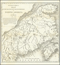
Fine detailed map showing the route for a proposed road from Augusta to the Canadian Border.
The title continues "Reconnaissance made in 1834 by Hartman Bache T.E. & Bt. Major Assisted by G. W. Ward 2nd Lt. 2nd Arty. and J. F. Cooper Bt.2nd Lt. 3rd Infy." The map used Greenleaf's map of Maine as its source with corrections by Ward and Cooper.
The map is centered on Bingham, extending south along the Kennebec River to Hallowell and Augusta and north to the Canadian line. The north is mostly unsettled, but the map names Moosehead Lake, the Bald Mountains, and three branches of the Penobscot River.
A good road network is shown between Waterville, Scowhegan Falls, Norridgewock, Solon, and more. There is good detail of the Old Canada Road with a note at the border that Quebec is 93 miles.