|
||

|

|
|

|
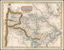
Rare separately issued map of Alaska and contiguous regions, showing the various routes to the Klondyke Gold Fields,.
One of the earliest obtainable Klondyke Gold Rush Guides, pre-dating Millory's "Map of Maps," issued the following year. The map illustrates the 5 routes tothe gold fields in red lines and indentifies in red letters the location of the "Gold Fields." Unlike Millroy's "Map of Maps" issued the following year, topographical details and location of the mines is not well known and expressed in the mos general terms. Similarly, Millroy would add 4 more routes the following year.
The map is a fine example of the duel purpose of guide and promotional tool, noting "From reliable sources it is learned that gold is to be found in almost every River, Creek and Lake, throughout Alaska and the Klondyke region. If a man cannot make $15 a day he quits in disgust and searches for a richer claim." Printed in 1897 and sold for the princely sum of 25¢ apiece, this detailed map of Alaska and the Canadian Northwest, and guide, presented the would-be prospector with a tantalizing picture of easy wealth. The map, "compiled from government and private surveys," shows a variety of routes to the Klondike gold fields.
The guide portion includes "Facts" for the traveler, another panel provides "How to reach the gold fields," and the last panel provides "Canada's new mining laws affecting the Klondyke region." There are ten mining laws detailed one of which states "A royalty of 10 per cent on the gold mined is imposed upon each claim yielding $500 a week, and 10 per cent on the exces over that amount a week." It was unlawful for any person to enter Canada under contract or agreement, furnish or to receive money, supplies or transportation in exchange for labor.
Five suggested routes are outlined, 1) Yukon River Route, 4069 miles, 2) Stikine River Route, 1508 miles, 3) Copper River Route, 1579 miles, 4) Taku River Route, 1551 miles, and 5) Chilcoot Pass Route, 1592 miles. Each route provided a breakdown for each leg of the journey.
The "Facts" provided deal largely with the discovery of gold, how to live in the area ("the best way to live is to imitate the Indians found in that country"), mineral resources in the area, and facts about the Yukon River. A side panel provides additional information for the prospector such as the climate and diseases, what to take for clothing, provisions, hardware, etc., the need for a medicine chest, and a section on revenues and tariffs as pretty much everything brought in or taken out willed be assessed a tariff.
An excellent presentation and quite a practical folder full of important information for the prospector
A fine example of this important map and guide.
In August 1896, three people led by Keish (Skookum Jim Mason), a member of the Tagish First Nations, headed north, down the Yukon River from the Carcross area, looking for his sister Kate and her husband George Carmack. The party included Skookum Jim, his cousin, known as Dawson Charlie (or sometimes Tagish Charlie), and his nephew Patsy Henderson. After meeting up with George and Kate, who were fishing for salmon at the mouth of the Klondike River, they ran into Nova Scotian Robert Henderson who had been mining gold on the Indian River, just south of the big dike. Henderson told George Carmack about where he was mining and that he did not want any "Siwashes" (meaning Indians) near him.
August 16, 1896, the Skookum party discovered rich placer gold deposits in Bonanza (Rabbit) Creek, Yukon. The news spread to other mining camps in the Yukon River valley. Gold was first discovered in Rabbit Creek, which was later named Bonanza Creek. The Bonanza, Eldorado, and Hunker Creeks were rapidly staked by miners who had been previously working creeks and sandbars on the Fortymile and Stewart Rivers.
News reached the United States in July 1897, at the height of a significant series of financial recessions and bank failures in the 1890s. The first prospectors arrived in San Francisco, California on July 15 and in Seattle, Washington on July 17, setting off the Klondike stampede. In 1898, the population in the Klondike may have reached 40,000, which threatened to cause a famine.
The boom brought many interesting people, including William Howard Taft (Camp Skagway #1), who went on to become a U.S. President; Frederick Russell Burnham, the celebrated American scout who arrived from Africa only to be called back to take part in the Second Boer War; and W. W. White, author and explorer.
Most prospectors landed at the Alaskan towns of Skagway and Dyea, both located at the head of the Lynn Canal. From these towns they traveled the Chilkoot Trail and crossed the Chilkoot Pass, or they hiked up to the White Pass and then to Lake Lindeman or Bennett Lake, the headwaters of the Yukon River. Here, the prospectors built rafts and boats that would take them the final 500-plus miles (800-plus km) down the Yukon to Dawson City, near the gold fields.
The miners had to carry a year's supply of goods over the passes to be allowed to enter Canada. At the top of the passes, the miner's met Canada's North West Mounted Police at a post that enforced the provisions regulation, as well as customs and duties. It was put in place to avert shortages like those that had occurred in the previous two winters in Dawson City, and also to restrict the entry of guns, particularly handguns, into British territory. Another reason was to keep out of Canadian territory the criminal element which had established itself in Skagway and the other Yukon Ports (then still claimed as British territory), as well as the fears by British and Canadian authorities about a possible armed takeover of the goldfields as an American territory.
Once the bulk of the prospectors arrived at Dawson City, most of the major mining claims of the region were already established. However, any major potential unrest with the idle population was averted with the firm authority of the NWMP under the command of Sam Steele.