This item has been sold, but you can enter your email address to be notified if another example becomes available.


|
||

|

|
|

|
Stock# 28620
Description
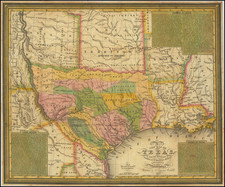
Attractive map of Texas and Indian Territory, colored counties, from J. David William's People's Pictorial Atlas.
Nicedetaild throughout Texas, including early railroad lines.
Shows dates various parts of Indian Territory were ceded to U.S. Shows towns, railroads, rivers, forts, mountains, Indian names, etc.

![[ Texas - Dallas to El Paso ] Flight Chart- Dallas Fort Worth to El Paso, U.S.A.](https://storage.googleapis.com/raremaps/img/small/98371.jpg)