|
||

|

|
|

|
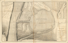
Rare Revolutionary War battle plan of White Plains, from Charles Smith's Monthly Military Repository, the first detailed plan of the battle of White Plains to be printed in the United States.
Following decisive victories in Brooklyn and Manhattan, British General William Howe allowed the American troops under the command of General George Washington to cross the Harlem River and take up a strong position on high ground near the village of White Plains. Unable to draw the Americans into open battle, Howe avoided a direct assault on their main force but did capture Chatterton's Hill on their left. Howe failed to follow up on the opportunity to flank the Americans, however, and instead chose to return his army to capture Fort Washington at the northern end of Manhattan, where Washington had left behind several thousand men.
The plan is derived from a section of a plan first issued separately by Faden in 1777, but with change from "Spencers Corp" on the American right is here labeled "McDougals Corps."
Smith's Repository (1796-1797) included instruction on military strategy, conduct, and clothing, extracts from histories of European wars and, more importantly descriptions of American Revolutionary battles. Most of the descriptions for the American battles were taken from the writings of Baron Steuben and Gen. Horatio Gates. Included were a series of revolutionary battle plans based on prototypes published in London. In 1797 Smith reissued the American material from the Repository in a single volume under the title The American War.
The maps from this work are very rare on the market, especially with original color.


![[Battle of Yorktown] Plan D'York en Virginie avec les attaques et les Campemens de l'Armee combinee de France et d'Amerique](https://storage.googleapis.com/raremaps/img/small/102603.jpg)