|
||

|

|
|

|
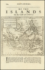
Fine example of this rare English Sea Chart of Southeast Asia, the Philippines and contigous regions, from the first edition of Herbertr's A New Directory for the East Indies.
Prepared in the style of a Portolan Sea Chart, Herberts chart covers the coasts of India, Malaysia, Philippines and the Indonesian archipelago. The top of Australia is shown as the Southern Land.
The lack of knowledge in the region is evidenced by the many incomplete southern and western coastlines in New Guinea and the islands to the south.
The map would appear to be very rare. The last appearance in AMPR was Jonathan Potter catalog 9 (1995).
The English mapmaker William Herbert (1718-95) traveled to India in about 1748 as a purser's clerk. Herbert's cartographic publishing started to take form in the late 1740s, when he set up a map and print shop on London Bridge. In 1758, with the encouragement of the East India Company, he introduced a new pilot guide, A New Directory for the East Indies. Herbert gathered superior sources than those used in Mount & Page's The Third Book, consulting such works as Mannevillette's Neptune Oriental, as well as the navigator William Nicholson and the cartographer Samuel Dunn. He often worked with colleagues, including Jefferys, Sayers, Dury, and Andrews, and is recorded as a seller of the famous Anti-Gallican map. In 1776 he retired, having apparently made a fortune. His business was carried on by Henry Gregory Sr.
![[Manila Bay] La Baie de Manille, Selon les Observations les plus recentes . . .](https://storage.googleapis.com/raremaps/img/small/59286.jpg)
![[Fort Gingee & The Great Mountain of Gingee]](https://storage.googleapis.com/raremaps/img/small/58792.jpg)
![[Ladrone Islands / Wanshan Archipelago] Ladronen Chine](https://storage.googleapis.com/raremaps/img/small/90221.jpg)