|
||

|

|
|

|
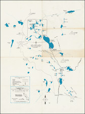
Interesting map of San Juan By The Sea and neighboring land, extending to the boundary of Rancho Boca de la Playa.
The map shows the subdivsion for San Juan By The Sea, and the lands owned by the Richfield Oil Company, Petroleum Services Co., John & Frank Forster (descendents of Don Juan Forster, who purchased the Mission and Mission Lands from Mexico in 1844), the Dana Point Company, Albert Prior, Soledad P. Landell, and the Dana Point Water Company, along with manuscript annotations for the construction of a proposed earth dyke.
The map was reportedly part of the S.H. Woodruff papers (the original developer of Dana Point and Hollywoodland) and may reflect work preparing for the deveopment of Dana Point, which commenced in about 1928 or 1929.
![[California Wine Advertising Graphic] Italian Swiss Colony Producers of Choicest California Wines Asti Colony Tipo](https://storage.googleapis.com/raremaps/img/small/83467.jpg)