


|
||

|

|
|

|
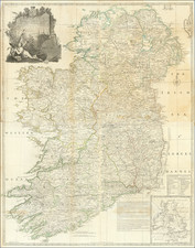
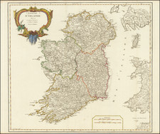
Exceptional example of this fine 4-sheet map of Ireland, baesd upon the most recent information and with extensive annotations.
Includes extensive 2 tables and a key map showing the location of Ireland within the British Isles.
Fine example of John Rocque's map of Ireland. Notes every town, hamlet, bishopric, country, forest, castle swam and road, along with offshore details, including the shoals in Georges Channel.
An elaborate title cartouche in the upper left quadrant shows the Irish Harp over two pensive bovines and a demurely positioned unclothed maiden.
Robert Sayer (ca. 1724-1794) was a prominent London map publisher. Robert’s father was a lawyer, but his older brother married Mary Overton, the widow of prominent mapmaker Philip Overton and the proprietor of his shop after his death. Mary continued the business for roughly a year after her marriage and then, in early 1748, it passed to Robert. Robert became a freeman of the Stationers’ Company later that year; his first advertisement as an independent publisher was released in December.
Sayer benefited from Overton’s considerable stock, which included the plates of John Senex. In the 1750s, Sayer specialized in design books and topographical prints, as well as comic mezzotints. In 1753, he, along with John Roque, published a new edition of Thomas Read’s Small British Atlas, the first of several county atlases that Sayer would publish.
Sayer’s business continued to grow. In 1760 he moved further down Fleet Street to larger premises at 53 Fleet Street. In 1766, he acquired Thomas Jefferys’ stock when the latter went bankrupt. In 1774, he entered into a partnership with John Bennett, his former apprentice. The pair specialized in American atlases, based on the work of Jefferys. They also began publishing navigational charts in the 1780s and quickly became the largest supplier of British charts in the trade.
Bennett’s mental health declined, and the partnership ended in 1784. As Sayer aged, he relied on his employees Robert Laurie and James Whittle, who eventually succeeded him. He spent more and more time at his house in Richmond. In 1794, he died in Bath.

![[Ireland / Sea Chart] Carte des Cotes Occidentales D'Irlande Reduite de la Carte de Stuart Amos Arnold et rectifee d'apres les Plans leves par M. MacKenzie Publiee Par ordres du Contr-amiral Decres Ministre de Marine et des Colonies . . . 1803](https://storage.googleapis.com/raremaps/img/small/63682.jpg)