
This item has been sold, but you can enter your email address to be notified if another example becomes available.


|
||

|

|
|

|
Stock# 28168
Description
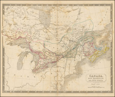
Detailed map of Eastern Canada and part of New England, from Heiden's Americanische urquelle derer innerlichen kriege des bedrängten Teutschlands. . .
The map extends west to Lake Champlain and the Richilieu River.
Shows a number of American and Brtish Forts and other points of interest at the outset of the French & Indian War.


![[ Missionary Map ] Canada Carte Indiquant Les Limites Des Dioceses, etc. Catholiques Romains Par G. Baillairge Ex-depute-ministre des Treavaux Publics de Canada 1893.](https://storage.googleapis.com/raremaps/img/small/37899.jpg)
![Amer. Sep. No. 24. Nouveau Cornouailles [Prince Rupert, Babine Lake &c]](https://storage.googleapis.com/raremaps/img/small/1783RB.jpg)