|
||

|

|
|

|
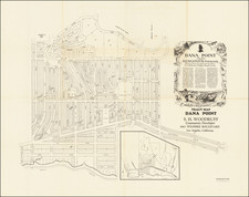
The first printed plan of Pismo Beach, California, almost certainly deriving from the original R.R. Harris survey of 1886 and subdvision of the town of El Pizmo in 1887, by the Pismo Beach Company.
The map shows the town plan, Wharf and Pizmo Beach Wharf Company, Hotel Pizmo, Stables, Bath House and a "Cottage" which looks a bit more like a small mansion.
Pismo Beach is part of the original 8,838-acre Rancho Pismo. Rancho Pismo was granted to Jose Ortega by Manuel Rinemo Goriod on November 18, 1840. The rancho was later acquired by Issac Sparks. In 1850, Sparks gave John Price El Pizmo Rancho instead of paying him wages in gold, as the deed shows a cost of $1 for the property. Upon Spark's death, John Michael Price and Captain David Mallagh received a share of the land. Price built up sizeable horse and cattle herds, which he moved onto the rancho. Mallagh owned a section of Rancho Pismo around the cave landing area (now Pirate's Cove), where he established a wharf business. Price purchased some of the property in 1854.
In 1875, Price took the first step toward funding the community of Pismo Beach when he built a hotel on the road from Arroyo Grande to the People's Wharf in Avila Beach. The hotel was not a success and Price had the hotel moved to the beach in 1884. In 1881, Price leased oceanfront land to the Meherin brothers to build a wharf and a warehouse. This wharf at the end of Main Street (Bolliver Avenue on this map) was successful and the hotel's new location was next to this operation. The school district and Post Office opened in 1888.
In February 1886, Price hired R.R. Harris to survey and design a map of the subdivisions of part of the Ranchos El Pismo and San Miguelito, and to also map out and draw a plan for a town to be called "El Pismo." This was initiated in April 1886. A year later, the Pismo Beach Company again subdivided part of the community and recorded a map of the "Town El Pizmo."
The map is of the utmost rarity and may be the only surviving example of the map. We were not able to locate any other examples of the map and a search of OCLC shows no printed material of any kind mentioning Pismo or Pizmo Beach printed prior to 1900.
The Schmidt Lithography Company was based in San Francisco. Max Schmidt, a German immigrant, founded his first printing business in 1873, and he was one of the first printers to use lithography on the West Coast. His plant burned twice, in 1884 and 1886, but by the 1890s he ran a factory in San Francisco, as well as branches in Portland and Seattle.
During the 1906 earthquake and fire the company’s premises were destroyed again. Schmidt quickly acquired a nearby paper factory and production continued practically uninterrupted. Within two years of the fire, Schmidt had rebuilt on the site of his former factory at the corner of Second and Bryant Streets.
Schmidt’s company was best known for its printed labels, but they also produced other items like separately-issued prints. The company was once the largest printing company on the West Coast and today they are remembered for the clock tower that still stands at Second and Bryant Streets.
![(Southern California Oil Fields) [27 original photographs of the Kern County Oil Fields, oil derricks, oil tanks of the Pacific Coast Oil Company]](https://storage.googleapis.com/raremaps/img/small/94688.jpg)
![(Stockton, California) [Manuscript Railroad Map of Stockton, California, on three sheets; Mormon Channel (Slough), Stockton Electric Railway; heavily annotated]](https://storage.googleapis.com/raremaps/img/small/96266.jpg)