|
||

|

|
|

|
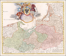
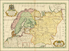
Nice example of this important early map of Scandinavia, from Olaus Magnus' Historia Olai Magni gothi archiepiscop upsalensis, de gentium septentrionalium, published in Basel in 1567.
The map is based upon Olaus Magnus' 9 sheet map of Scandinavia ( Carta Marina et Descriptio Septemtrionalium Terrarum ac Miabilium Rerum in Eis Contentarum Digilentissime Elaborata Anno Dni 1539), published in Venice in 1539, which is known in only 2 copies. Antonio Lafreri also produced a reduced size example of the map in 1572. Magnus listed among his intentions in creating the map that he wished to show the regions taken by the Protestants from the Catholics in Scandinavia and to improve upon the then utilized Ptolemaic information for mapping Scandinavia.
Olaus Magnus (1490 - 1557) was a Nordic historian renowned for Pohjoisten kansojen historia [A History of the Nordic Peoples] and as an author of a 9 sheet map, Carta marina, closely connected with the same. He was a highly learned clergyman who is often referred to as the last Roman Catholic bishop of Swedish Finland. In reality he did not attend to his bishop vocation for even as long as a day, because King Gustav had changed Sweden into a land of Lutheranism and could not approve a Catholic bishop appointed by the Pope. Olaus Magnus lived in exile for the rest of his life and died in Rome.
From 1518 to 1519, Olaus Magnus made a journey across Sweden. During his trek, he collected information connected with nature as well as the people and their habits, which serve as the foundation of his works. Pohjoisten kansojen historia [A History of the Nordic Peoples], which was published in 1555, was the first literary and pictorial presentation of Lapland. Olaus relates his own eyewitness observations of Tornionlaakso Valley, as his journey extended as far as Pello. With respect to the rest of Lapland, his description is based on antique and medieval literary sources and oral accounts which were mixed up with plenty of imagination and prejudices.
Magnus' original 9 sheet map was the first large scale regional map of Europe. As noted by Nordenskold, at the time of its publication, there was no similarly sized map for any other country in Europe. The map is also the inspiration for a number of the great contemporary sea monsters of the period, which were copied by Munster, Ortelius and others.
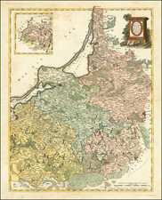
This 1567 edition of Magnus' work presents a unique interpretation of the original 9 sheet map. As noted by Bill Ginsburg:
The 1567 Olaus Magnus possesses a certain visual appeal. Its angled upper corners are vaguely reminiscent of the 1539 prototype . . .
The monogram THW 1567 at the lower right are the initials of Thomas Weber, the woodcutter of the map. Until recently, it had been believed that the initials were FW and were those of Johan Baptiste Fickler of Weil or Fickler Weylensis, who translated Magnus's work into German. The map provides striking imagery and a much larger presentation of Scandinavia than the two other copies of the Magnus map which appeared in earlier editions of the book and which are significantly smaller in size.
This edition of the map is relatively scarce on the market. We were only able to located two examples of the map in dealer catalogues in the past 25 years.
![Les Estats de la Couronne d'Arragon en Espagne ou sont l'Arragon Royaume, la Catalogne Princip[au]té, la Valence Royaume, et les Isles de Maiorque... 1653](https://storage.googleapis.com/raremaps/img/small/80239.jpg)