|
||

|

|
|

|
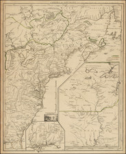
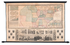
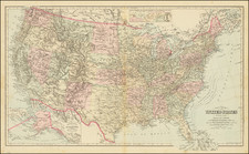
A nice example of Weiland's rare map of the United States dated 1847, which includes the German or Mainzer Colony (Deutsche Colonie des Mainzer Vereins), with a key identifying the location of the Districts of the Republic of Texas (36 are named).
Marvelous large format map of the United States, which includes the names of both C.F. Weiland and H. Kiepert. The map includes a marvelous treatment of the Western Territories of the United States, including a massive Neu-Californien, Tomahawk shaped Indian Territory, large Oregon Territory, extending to the Rocky Mountains, and large Missouri Territory, pre-dating the appearance of Nebraska Territory, Kansas, etc. There is also a very curious territorial configuration to the west of Iowa which does not seem to be named.
The map shows a number of early roads, most notably in the West. Captain Sutter's New Helvetia settlement (Colonie New Helvetia des Ca pt. Sutter) is noted, but pre-dating the discovery of gold. Many Indian Tribes are named, more so than in most contemorary maps. The topography and hydrography are also quite well executed.
The map is extremely rare, this being the first example we have seen in nearly 20 years.