|
||

|

|
|

|
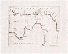
Rare and highly influential plan of the Portobello, Panama, showing the Battle of Portobello based upon the sketches of Phillip Durrell, a Lieutenant in the English Navy, which would become one of the most famous English triumphs over the Spanish during the War of Jenkin's Ear (known in Europe as the War of Austrian Succession). The English translation of the title is "This Plan of the Harbours, Towns and Forts of Porto Bello Taken by Edward Vernon Esqu. Vice Admiral of the Blue on the 22nd. November 1739 with Six Men of War Only."
The plan provides a highly detailed treatment of Spain's most prized harbor on the Central American coastline, showing the location of the town of Portoello, the two castles and Fort St. Jeronimo, which guarded each side of the harbor, along with soundings, the locations of the rivers which fed the harbor, and detailed, if somewhat stylized, topographical details. Oriented with southeast at the top, the plan shows Vernon's 5 ship attack force entering the harbor (with a sixth ship remaining outside the harbor, which was protected by a Spanish force of 4 large ships and 2 smaller ships. The key at the bottom identifies each of the ships, along with some commanding officers and other points of interest.
Admiral Vernon would later commission paintings of the battle attributed to Samuel Scott, which were painted from the diagrams of the Harbor drawn by Captain James Rentone and Captain Phillip Durrell of the Burford, whose ship is identified as "E" in the present plan. Durell (1707-1766), would reach the rank of Vice Admiral, with noteworthy commands in the Battle of Minorca (1756) and the Siege of Quebec (1758).
Durrell's Plan of Portobello was one of the most detailed and influential plans of this highly important trading center on the Panama Coastline. First discoverd in 1500 by Rodrigo de Bastidas, and named by Diego de Nicuesa in 1509, Porto Bello was for 3 centuries an important Spanish Harbor and trading outpost. The first attempt to settle Portobello was made by Diego de Albites in 1518, but was abandoned within a year, in favor of Nombre del Dios, which would become the first important Spanish trading port on the coastline of Central America.
Following Sir Francis Drake's attacks on Nombre del Dios in 1572 and 1573, Spain reconsidered the location of this important trading port. In 1586, Italian engineer Juan Buatista Antonelli recommeded to King Felipe of Spain the relocation of Nombre del Dios, and the King subsequently ordered the relocation to the harbor of San Felipe de Puertovelo (Portobello) on March 20, 1597.
Portobello was first attacked by Captain William Parker in 1602 and again by Henry Morgan (June 1668), Bartholemew Sharp, Willaim Dampier and Lionel Wafer (1679), and finally by Edward Vernon in 1739, as depicted in the present plan.
Portobello was a major Spanish naval base on the Spanish Main. Following the failure of an earlier British naval force to take Portobello in 1727, then-Vice Admiral Edward Vernon had repeatedly claimed he could capture it with just "six ships". Following his appointment to command the Jamaica Station, Vernon organized an expedition with just six ships, despite criticism that this was far too few. Vernon was a strong advocate of small squadrons hitting hard and moving fast rather than larger slower-moving expeditions that were prone to heavy losses through disease.
Vernon's force appeared off Portobello on November 20,1739. The British ships entered the bay prepared for a general attack, but a wind coming from the east obliged Vernon to concentrate his ships on the Todo Fierro harbour fort. The Spanish garrison was caught unprepared. When some Spaniards began to fly from several parts of the fort, several landing parties were sent inshore. The British sailors and marines scaled the walls of the fort, struck the Spanish colors in the lower battery and hoisted an English ensign and the Spaniards surrendered the fort. Of the 300-man Spanish garrison, only 40 soldiers led by Lieutenant Don Juan Francisco Garganta had remained in the fort.
Once capturing Todo Fierro, Vernon shifted his ships against Santiago Fortress, sinking a Spanish sloop and causing other damages. At dawn on the following morning, the Spaniards requested terms of surrender. Governor Francisco Javier Martínez de la Vega y Retes surrendered at the afternoon. Portobello was occupied by the British at the cost of three dead and seven injured. The British occupied the town for three weeks, destroying the fortress and other key buildings and ending the settlement's main function as a major Spanish maritime base.
The capture of Porto Bello was seen as a popular triumph throughout the British Empire and the name Portobello became frequently used to commemorate the battle such as the Portobello Road in London, the Portobello district of Edinburgh and Porto Bello in Virginia. The victory was particularly well received in America, where the Spanish had been preying on British shipping. Admiral Vernon became a popular hero, and himself was commemorated in several names, perhaps most famously Mount Vernon the estate of George Washington.
An English version of the plan by Harding & Toms appears periodicatlly on the market, most recently offered by Sothebys on December 2, 1999 (Lot 187). The Covens & Mortier edition has only been offered once in a dealer catalogue in the past 30 years (Arkway 2003), with no recorded auction appearances in AMPR or ABPC.
Pierre, or Pieter, Mortier (1661-1711) was a Dutch engraver, son of a French refugee. He was born in Leiden. In 1690 he was granted a privilege to publish French maps in Dutch lands. In 1693 he released the first and accompanying volume of the Neptune Francois. The third followed in 1700. His son, Cornelis (1699-1783), would partner with Johannes Covens I, creating one of the most important map publishing companies of the eighteenth century.
![La Florida [with] Guastecan [with] Peruviae Auriferae Regionis Typus](https://storage.googleapis.com/raremaps/img/small/84003.jpg)