|
||

|

|
|

|
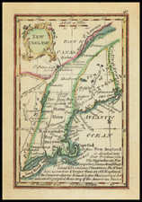
Published in the October, 1775 issue of the Pennsylvania Magazine , this was the first map printed in America to focus specifically on the Lake Champlain area which would be a major theater of war during the American Revolution.
Wheat & Brun note: "This map shows the key waterway leading from Lake George to the St. Lawrence River with the primary geographical features, forts, and the names of some of the landowners in the area." Guthorn (American Maps and Map Makers of the Revolution) 2(5): "[Robert] Aitken ... from January 1775 to June 1776 … published The Pennsylvania Magazine or American Monthly Museum . This organ was edited by Thomas Paine and represented the partisan views of the publisher. It contained a number of maps of interest."