|
||

|

|
|

|
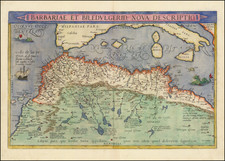
Rare sea chart of the western part of the Mediterranean Sea between Gibraltar and Sicily, including the Balearic Islands, Corsica and Sardinia, originally engraved by Jacob Colom circa 1658.
The map includes 8 small insets with maps and plans. includes 4 inset tables naming more than 50 coastal locations.
This map has previously been described as a later edition of Doncker's map of the Western Mediterranean, but there is no evidence of an earlier edition which we can locate. To the contrary, it seems almost certain that this map was originally issued by Jacob Colom under the title Westerdeel der Middelantsche Zee Nieulyx Beschreven door Iacob Colom. Zacherakis 1401/942 lists a map of the Eastern Mediterranean by Doncker, circa 1676, with a similar title and a note "De Novo Emendatum et Auctum" which is also present in this map. The Colom size is identical and includes the same Insets of ports: a) Bona; b) Saragoßa; c) Baya de Agde in Languedoq; d) P. Farina; e) Sufa; f ) Sardinia (south coast) ; g) Alcol ; h) Alzyra and the same four text boxes listing the names of islands on the African coast, those near Sicily, Sardinia, Corsica and Majorca, islands of Provençe, and Italian islands.
As noted by Ashley Baynton Williams in Mapforum:
A reference to the plates from [Colom's Zee-Atlas] is found in a Notary Act of 1663, ordering Colom to give them to his landlord Nicolaas Visscher (a prominent map-maker, also) as security against his unpaid rent. Presumably, the debt was never paid, as no subsequent issues by Colom are known. It would appear that on the death of Colom, Visscher, who had no interest in publishing sea-atlases, sold the plates to Hendrick Doncker, because some of the plates subsequently re-appear in his 'Vermeerderde Zee-Atlas', from 1676 onwards. We can locate no other examples of either the Colom or Doncker edition of this sea chart offered for sale in the past 30 years.
Hendrik Doncker was a prominent bookseller in Amsterdam best known for his sea charts and nautical atlases. He issued his own original charts, which he updated frequently, and also worked with colleagues like Pieter Goos, for example to produce the pilot guide, De Zeespeigel. He died in 1699, after fifty years in business. His plates then passed to Johannes van Keulen.
![Carte generale de l'Empire romain [des Sarrasins]](https://storage.googleapis.com/raremaps/img/small/82000.jpg)
![Neuester und exacter Plan und Prospect von der Stadt Vestung Bay und Fortification Von Gibraltar…1733 [with view of Cadiz]](https://storage.googleapis.com/raremaps/img/small/91413.jpg)
![Asiae, Quae Vulgò Minor Dicitur, et Syriae tabula geographica, quantum per subsidia licuit elaborata, opere, si quod aliud in antiqua geographia, arduo. Quam tabulam clariss. Dom. Comes de Caylus in aere incidi curavit. [Asia, commonly called the Lesser, and Syria, a geographic map, as much as it was possible to elaborate with the aids, a work, if any in ancient geography, arduous. This map the most illustrious Lord Count of Caylus had carved in copper.]](https://storage.googleapis.com/raremaps/img/small/100258.jpg)