|
||

|

|
|

|
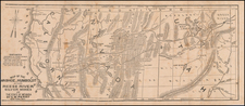
Rare and highly important map of the Northwest, the first ever appearance of the Oregon Trail on a printed map.
Lapie's map was prepared to illustrate Robert Stuart and Wilson Price Hunt's account of the overland expedition from Astoria to the Missouri, which resulted in the discovery of the South Pass & the Oregon Trail. In 1810, John Jacob Astor of the American Fur Company, outfitted an expedition (known as the Astor Expedition) under Wilson Price Hunt to find a possible overland supply route and trapping territory for fur trading posts. Fearing attack by the Blackfoot Indians, the overland expedition veered south of Lewis and Clark's route into what is now Wyoming and in the process passed across Union Pass and into Jackson Hole, Wyoming. From there they went over the Teton Range via Teton Pass and then down to the Snake River in Idaho. The expedition abandoned is horses at the Snake River, made dugout canoes, and attempted to use the river for transport.
After a few days' travel the party discovered that steep canyons, waterfalls and impassable rapids made travel by river impossible, forcing them walk the rest of the way to the Columbia River, where they made new boats and traveled to the newly established Fort Astoria. The expedition demonstrated that much of the route along the Snake River plain and across to the Columbia was passable by pack train or with minimal improvements, even wagons.
After several month, American Fur Company partner Robert Stuart led a small group of men back east to report to Astor. The group planned to retrace the path followed by the overland expedition back up to the east following the Columbia and Snake rivers, however, fear of Indian attack near Union Pass in Wyoming forced the group further south where they luckily discovered South Pass, a wide and easy pass over the Continental Divide. The party continued east via the Sweetwater River, North Platte River (where they spent the winter of 1812-1813) and Platte River to the Missouri River, finally arriving in St. Louis in the spring of 1813.
The route used appeared to potentially be a practical wagon route, requiring minimal improvements, and Stuart's journals provided a meticulous account of most of the route. Because of the War of 1812 and the lack of U.S. fur trading posts in the Oregon Country, most of the route was unused for more than 10 years.
Because Jacob Astor so closely guarded the information brought back by Hunt & Stuart and did not release their accounts until years later, the only contemporary account being in volumes 10 & 12 of a rare French journal, Nouvelle Annales Des Voyages, accompanied by Lapie's equally rare map, which faithfully reports Hunt & Stuarts discoveries. As noted by Wheat in his 3 page description of the map:
The first map of importance to appear in 1821 was by a Frenchman the Chevalier Lapie. It was published in Nouvelle Annales des Voyages, in Paris, and purports to show the routes of the Astorians Wilson Price Hunt (westward) and Robert Stuart (eastward) a decade earlier. The map is well constructed, and has long been praised as a remarkably accurate representation of their journeyings. It seems to have been largely based on the Lewis and Clark map of 1814, but in its new element it was a notable performance..."
There is no English edition of of the map. Wheat states that the map is of tremendous cartographic importance and surmised that Lapie had access to a manuscript map furnished by Gallatin or Astor. At least one writer believes that Astor in fact hand picked the Nouvelle Annales to publish the work, state:
[Lapie] seems aware of Wilson Price Hunt's travels through the Wind River Valley and Union Pass, as well as Robert Stuart's return through Jackson Hole and South Pass. Indeed Lapie's map was published along with an abridgement of Wilson Price Hunt's westward route and Robert Stuart's "traveling memoranda" of his return eastward via Jackson Hole, the Wind River Mountains and what came to be known as "the South Pass"-the route of American migration to Oregon and California. Perhaps Lapie's omission (of the Tetons) was due to American Fur Company mogul, John Jacob Astor himself who, while insisting that the news of the expedition be first published in the prestigious Nouvelles Annales de Voyages, by no means wished to provide explicit directions to his competitors in the fur trade including the British Northwest Company.
Picturing Jackson Hole and Grand Teton National Park, William H. Goetzmann, Chapter 18 .
The Streeter copy of the map, with the text, brought $850.00 at auction in 1968. This is the first example of the map we have had in more than 10 years.
![[ Queen Anne's War - Failed Attack on French Canada -- Petition to Queen Anne from the Colony of New York seeking reimbursement for a failed conquest of New France during Queen Anne's War ] To the Queens most Excellent Majesty . . . 1709](https://storage.googleapis.com/raremaps/img/small/85409.jpg)