|
||

|

|
|

|
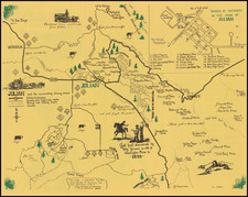
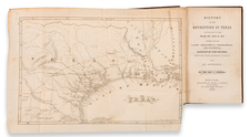
Extremely rare separately issued map of the newly created Republican Federation of Mexican States, published by A.H. Dufour, including one of the only known references to the Republic of Fredonia, considered to be the first attempt to create an indepdent Texas.
Among its most interesting features are the "Republique De Fredonia" (formed by the province of Texas December 16, 1826, as noted on the map). Wheat, referring to the 1837 edition of the map, notes that a significant portion of the map is derived from Escalante and Stephen Long. A number of the mythical lakes and rivers of the west are noted. Wheat makes no mention of the Republique of Fredonia, so we stongly suspect it was only included in this early edition of the map. We also note the existence of an 1837 edition of the map, with the date printed in the title.
We believe this to be an earlier edition of the map, published shortly after Mexico's independence and without several of te annotations referenced by Wheat
The map depicts the short lived "Republic of Fredonia," a reference to the Fredonia Rebellion, the first attempt to create a separate independent Republic in Texas. The Fredonian Rebellion (December 21, 1826 - January 31, 1827) was the first attempt by Anglo settlers in Texas to secede from Mexico. Led by empresario Haden Edwards, a group of Texas settlers declared independence from Mexican Texas and created the Republic of Fredonia near Nacogdoches, Texas. The republic encompassed land the Mexican government had granted to Edwards in 1825 and included areas that had been previously settled. Edwards's actions soon alienated these established residents, and the increasing hostilities between them and settlers recruited by Edwards led the Mexican government to revoke Edwards's contract.
In late November 1826, a group of Edwards's supporters took control of the region by arresting and removing from office several municipality officials affiliated with the established residents. A month later, the Edwards supporters declared their independence from Mexico. Although the nearby Cherokee tribe initially signed a treaty to support the new republic, overtures from Mexican authorities and respected empresario Stephen F. Austin convinced tribal leaders to repudiate the rebellion. On January 31, 1827, a force of over 100 Mexican soldiers and 250 militiamen from Austin's colony marched into Nacogdoches to restore order.
The rebellion led Mexican President Guadalupe Victoria to increase the military presence in the area. As a result, several hostile tribes in the area halted their raids on settlements and agreed to a peace treaty. The Comanche abided by this treaty for many years. Fearing that through the rebellion the United States hoped to gain control of Texas, the Mexican government severely curtailed immigration to Texas. This new immigration law was bitterly opposed by colonists and caused increasing dissatisfaction with Mexican rule. Some historians consider the Fredonian Rebellion to be the beginning of the Texas Revolution.
Streeter notes a copy of this map dated 1837, with the publisher address listed as Chez Basset rue St. Jacques No. 64. The present example is labeled Maison Basset Rue de Seine No. 33. Rue de Seine was the first location of "Maison Basset." OCLC lists 3 copies of the map with the publisher named as "Chez Basset," but no examples with Maison Basset.