![[ First Printed Map of San Francisco Bay ] Plan Du Port De St. Francois Situe sur la cote de la Californie . . . By Jean Francois Galaup de La Perouse](https://storage.googleapis.com/raremaps/img/small/90983.jpg)


|
||

|

|
|

|
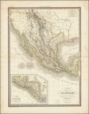
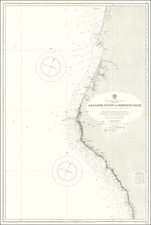
Highly desirable map of San Francisco from the La Perouse's Voyages, the first obtainable map of San Francisco Bay.
During his round the world voyage, La Perouse coasted southward along the California coast in 1786, passing San Francisco on September 10 and arriving in Monterrey on September 13, where he remained for 9 days, before setting out for the Philippines. While La Perouse's chart of Monterrey is from original sources, the map of San Francisco is based upon a chart secured by La Perouse from the pilot Mourelle in Manila, or was obtained by the editors of La Perouse's Voyages from European sources. It derives from the Dalrymple Plan of 1789 and is almost identical to the Plano del puerto published by the Mexican Government in 1825. The information derives from Canazares chart of 1776 and Camacho's charts of 1779 and 1785. The map includes 21 place names, including Alcatraz, the Presidio,. Merced, the Mission of San Francisco, and other current landmarks.
A fundamental map for San Francisco collectors, the earliest obtainable map of San Francisco.