The item illustrated and described below is sold, but we
have another example in stock. To view the example which
is currently being offered for sale, click the
"View Details" button below.


|
||

|

|
|

|
Stock# 27038
Description
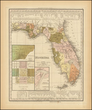
First edition of Tanner's map of Florida, with insets of Pennsacola, Tallahassee and the Harbor of St. Augustine, from his New Universal Atlas.
In this first edition, there is a massive Indian Reserve which appears between Mosquito County and Alachua County, along with a line annotations stating "Undetermined Indian Boundary" and two othr Indian Boundary Lines. There is a road traversing the southern swamps identified as "Tracks of the Indians." The Arrondondos Grant is shown in both Monroe County and Alachua County.
Shows many early forts, roads, rivers, lakes, the Evergades, etc.

![Island of Cuba (Spanish) and Jamaica (British) [also South Florida, Bahamas and Cayman Islands]](https://storage.googleapis.com/raremaps/img/small/98323.jpg)
![[Florida and Gulf Coast] The Coast of West Florida and Louisiana . . . [with] The Peninsula and Gulf of Florida or Channel of Bahama with the Bahama Islands . . .](https://storage.googleapis.com/raremaps/img/small/66344.jpg)