|
||

|

|
|

|
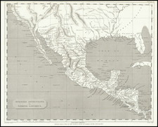
Second edition of this detailed and well engraved map of Texas, Upper California and Mexico, engraved by John Dower for Milner's Descriptive Atlas of Astronomy and Physical and Political Geography.
Shows the newly established boundary of the the Treaty of Guadalupe Hidalgo separating Mexico and Texas on the eve of the California Gold Rush.
I this edition of the map, the massive Texas and Upper or New California have been replaced with a more normally configured Texas and California although both are still not in their final configurations, with New Mexico Territory and Utah Territory now shown. The route from Council Bluffs to the Pacific is illustrated, along with a number of early Western Forts. The Upper California Missions are all named and the name Vegas appears where the town of Las Vegas will ultimately flourish starting about 100 years later. A number of Indian Tribes are also named.
In addition to the new Territorial borders, Sacramento City and a number of the early gold rush towns in the areas are now named and Salt Lake City is shown, among other updates.
A link to the first edition of the map can be found here: /gallery/detail/15240
![[Texas & Oklahoma] Amer. Sep. No. 55. Partie Des Etats-Unis](https://storage.googleapis.com/raremaps/img/small/93537.jpg)
![[ Southwest & Texas ] Le Nouveau Mexique, Avec La Partie Septentrionale De L'Ancien, ou De La Nouvelle Espagne](https://storage.googleapis.com/raremaps/img/small/99395.jpg)