


|
||

|

|
|

|
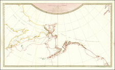
Striking North Polar Map Featuring Detailed Vignettes of Whaling--Final State!
Fine example of Hondius’ map of the North Polar regions, here in its seventh and final state.
The map shows the geography of the globe from 50°N latitude. The seas between Tartary, in Asia, and Baffin Bay, in North America, are left open. However, all of the toponyms in northern Asia, Europe, and North America are named for explorers who hoped to chart just this area—they were in search of a navigable seaway between Europe and China.
Eastern Tartary is labeled as “incognita,” or unknown. The eastern shore of Nova Zemla is also unfinished, as is that of Spitsbergen. Rivers and lakes are included inland in Europe and Asia, perhaps suggesting a river-bound passage east.
Iceland is well-delineated, with Mount Hekla in mid-explosion. East of Ireland is a tiny island called “Brasil.” Hy Brasil was a wandering island thought to appear from time to time to sailors through the mist. The myth dates back to the Medieval period. Its existence was uncertain, but still plausible enough to include here.
Greenland, a huge island, has a snaking shoreline with the eastern and northern sections unfinished. Access to Baffin’s Bay is through the Davis Straits. A tiny inlet separates Greenland from North America; this area was perpetually iced over when Europeans encountered it in this period, making the geographic relationship between the landmasses unclear.
Farther south is Hudson’s Bay; the names of Hudson, James, Button, and other explorers are the defining features of this area. James Bay—named for Thomas James who led an expedition to the area in 1631—has additional place names referenced in a key.
Two cartouches grace the map’s surface. One, near the North Pole, includes the title and maker. The other, in Tartary, was empty in early states of the map and later included the publishing information of Frederick de Wit.
The most alluring part of this map is the series of vignettes that surround the circular chart. All four corners show scenes of whaling and sealing. Men in masted ships send out smaller boats to pursue the animals. They harpoon the creatures, tow them ashore, and there process the meat and render the fat. These are meant to celebrate the burgeoning Dutch whaling industry at work on the eastern coast of Labrador; this is the first map to feature Dutch toponyms in that area.
History and states of the map
The map was initially published by Henricus Hondius. He wanted to create an updated map that departed from the four islands of Mercator’s conception of the North Pole. The proof state and a second state, both lacking the vignette decorations, appeared in English editions of Hondius’ atlas in 1636. In the German edition of the atlas, also published in 1636, the map appeared in a third state with the vignettes included.
Sources for the map included the aforementioned Thomas James. He also drew on Henry Briggs’ map of 1625. This foundational map of North America was included in Samuel Purchas’ voyage collection, Hakluytus Posthumus, or Purchas his Pilgrimes, one of the most well-known travel books ever published in English. It was the first to name Hudson’s Strait and Bay.
The plate was later used by Jan Jansson, who added his name to a fourth state. Frederick de Wit next acquired the plate, re-issuing it in ca. 1676. De Wit removed Jansson’s imprint (fifth state), added his own name (sixth state), and this was later shortened to “PER F.DE WIT” (seventh state).
These later states also featured in the atlases of Nicolaas Visscher and then Adriaan Braakman (1709). Louis Renard also included in an atlas (1715, seventh state) and again by Reiner and Joshua Ottens (1739). The plate thus had a substantial life in print of 103 years.
- State 1, 1636: Proof state with blank cartouches and no vignettes.
- State 2, 1636. Central cartouche carries the title and Hondius’ imprint.
- State 3, 1636. Whaling vignettes added.
- State 4, pre-1664. Hondius’ imprint removed and replaced by that of Jansson.
- State 5, ca. 1676. Jansson’s imprint removed.
- State 6, ca. 1676. Frederick de Wit’s imprint added in the central cartouche. The cartouche in Tartary is now filled in with de Wit’s shop address.
- State 7, 1715. De Wit’s imprint changed to PER F.DE WIT. Cartouche in Tartary is blank again. Fol. 3 is at the top right. Iceland and Nova Zemla are re-engraved and the Prime Meridian is shifted ten degrees east.
The search for a Northeast Passage to the eighteenth century
A Northeast Passage was a popular topic for states and navigators from the sixteenth century, just like the more well-known Northwest Passage. In 1553, Hugh Willoughby, with backing from London merchants, sailed north. Willoughby’s crew got separated from their navigator, Richard Chancellor, rendering them lost. Russian fisherman found their frozen bodies the following summer.
Jacon van Heemskerck sought the Northeast Passage beginning in 1596, accompanied by Willem Barentsz as pilot. They discovered what they called Spitsbergen, which is now known as part of the Svalbard Archipelago. Their ship became locked in the ice and they were forced to winter in situ, the first time a ship had done so. In the spring, they escaped in open boats; Barentsz died, but van Heemskerck made it to the coast of Lapland.
By the seventeenth century, Russian traders had found a continuous sea route, the Mangazeya Seaway, from Arkhangelsk to the Yamal Peninsula. From there, adventurers would portage to the Gulf of Ob. However, sailing around land farther east proved difficult, if not impossible, in the early modern period. Voyages pioneering parts of the Northeast Passage continued, however. For example, Fedot Alekseev and Semyon Dezhnev sailed from the Kolma River, around the Chukchi Peninsula, and into the Pacific in 1648, proving that Asia and North America were not connected.
The search for a Northwest Passage to the eighteenth century
Today, the most famous expeditions in search of the Northwest Passage are those that took place in the mid-nineteenth century, including the ill-fated Franklin voyage. However, finding a passage to Asia via a northern route was a centuries-old endeavor. Indeed, Ptolemy, in the second century CE, suggested that there was a sea route between Europe and East Asia. The expansion of the Ottoman Empire in the fifteenth century led Columbus and De Gama to explore for alternative access to Asian markets to the west and south. The information they brought back led Europeans to look to the northwest and northeast for a shorter, yet treacherous and icy, way to China.
The first recorded search for the Northwest Passage was the voyage of John Cabot in the late fifteenth century, following in the wake of Norse voyages to North America that occurred in the eleventh century. With the support of Bristol merchants, Cabot landed in Newfoundland in 1497. The following year, in a voyage supported by Henry VII, he left with five ships and 200 men; the squadron never returned. In the early sixteenth century, John’s son, Sebastian, led several voyages to what is today Canada.
Early English and French voyages to North America were constantly on the look-out for passages that might lead to the Pacific. For example, Jacques Cartier led an expedition at the behest of Francis I of France. Cartier ranged over the coasts of Newfoundland and the Gulf of St. Lawrence; he was the first European to contact Prince Edward Island, which, alas, was not the Northwest Passage. A second voyage took Cartier to the location of Quebec, which he claimed for France.
The Spanish too sought the Northwest Passage. They originated the toponym of the Strait of Anian, a displacement of a place name from Marco Polo’s writings, which soon caught on with mapmakers across Europe. Conquistador Hernán Cortés funded the voyage of Francisco de Ulloa from Acapulco north in search of the western entrance to the Passage. He got to the Gulf of California before turning back.
The English did not mount many expeditions during the reign of Henry VIII, who was more focused on the power balance in Europe, but under Elizabeth I many voyages set out to the northwest. Martin Frobisher, a privateer, led three attempts on the Passage in 1576, 1577, and 1578. He thought that he had discovered gold in Frobisher Bay, on Baffin Island, but it turned out to be iron pyrite.
John Davis also led three expeditions north, in 1585, 1586, and 1587. He sailed along Greenland, Baffin Island, and Labrador, as well as charted the Davis Strait. He also found the entrance to Hudson Strait, which would be named for Henry Hudson thirty years later.
John Smith searched for the passage while sailing up Chesapeake Bay in 1608. He did not find it, but he wrote to his friend Hudson that he thought it still might lie just to the north. In the employ of the Dutch East India Company (VOC), Hudson set out in 1609. He first ventured up the Hudson River; while this was again no Northwest Passage, it did help the Dutch to colonize New York, or New Amsterdam as they called the settlement. In 1610, Hudson tried again, this time entering the eponymous Hudson Bay. His ship was trapped in the ice, his crew mutinied, and Hudson, his son, and seven others were set adrift in a small boat, never to be seen again.
One of the mutineers who escaped trial was Robert Bylot, who accompanied Thomas Button on his Arctic voyage in 1612-13. Bylot also accompanied William Baffin to the Arctic in 1615 and 1616; their reports of Baffin Bay were considered fantastic until revisited by John Ross two hundred years later.
Two further explorers, Luke Foxe and Thomas James, went on separate voyages in 1631. Foxe investigated the western shore of Hudson Bay, while James visited the south. These were the last English attempts on the Passage for a century, but the names of Frobisher, Davis, Hudson, Button, Baffin, Foxe, and James are still sprinkled liberally in the high latitudes of the Arctic. The Hudson’s Bay Company (HBC) was founded in 1670, but they focused on trade, rather than exploration, until new attempts were made in the 1720s.
De Wit (1629 ca.-1706) was a mapmaker and mapseller who was born in Gouda but who worked and died in Amsterdam. He moved to the city in 1648, where he opened a printing operation under the name of The Three Crabs; later, he changed the name of his shop to The White Chart. From the 1660s onward, he published atlases with a variety of maps; he is best known for these atlases and his Dutch town maps. After Frederik’s death in 1706, his wife Maria ran the shop for four years before selling it. Their son, Franciscus, was a stockfish merchant and had no interest in the map shop. At the auction to liquidate the de Wit stock, most of the plates went to Pieter Mortier, whose firm eventually became Covens & Mortier, one of the biggest cartography houses of the eighteenth century.
![[Battle of Berlin] План г. Берлин 1:25000](https://storage.googleapis.com/raremaps/img/small/68524.jpg)
![Drapeaux et Armes de L'U.R.S.S. et des 15 Republiques Socialistes Sovietiques Federees [Flag and Arms of the URSS and the 15 Federated Soviet Socialist Republic]](https://storage.googleapis.com/raremaps/img/small/94638.jpg)
