
This item has been sold, but you can enter your email address to be notified if another example becomes available.


|
||

|

|
|

|
Stock# 26854
Description
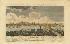
Highly detailed folding map of London in original slip case.
The map is exceptionally detailed, including all of the buildings constructed up to 1797. Bowles regularly updated this map, making it one of the most up to date maps of London published during the perod.
The reference key notes nearly 200 churches and principal buildings, with a coordinate locating them on the map for ease of use. A fine example of this 18th century map of London.
Condition Description
Case Map. Segmented and laid on linen, with original marbled slip case and paste down title.
Reference
Howgego, J. 158a.
![[ Roman Britain ] Britannicae Insulae in quibus Albion Seu Brittania Major, et Ivernia Seu Brittania Minor juxta Ptolemaei mentem divisa . . . 1778](https://storage.googleapis.com/raremaps/img/small/103269.jpg)
![[St. Helena] The True Description of the Island of Ascention lyeing under 8 degrees on ye South syde of ye Equinoctiall lyne.](https://storage.googleapis.com/raremaps/img/small/78964.jpg)