|
||

|

|
|

|
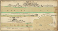
Rare map of the area around the Cape of Good Hope, which includes an exceptionally detailed look at the Dutch settlement in the region, including the identification of the farmers of the Hollandsche Oost-Indishe Compagnie who were then in residence, as well as a number of VOC officials.
The present example of the map is apparently the third known example, which to date had been classified by scholars as having been created by an anonymous source. In a detailed article written in 1987 by Mieke Scholte, Scholte determines that the map derives from a manuscript map made by the VOC. As noted by Roger Stewart in his soon to be published article:
In his Beschryvinge van de Kaap der Goede Hoop, Francois Valentijn describes a source: 'the handsome drawing ... put at my disposal by Governor Willem Adriaan van der Stel ... made just before arrival of H.E., (on which) one can see very plainly the plan of the town, together with its extensions outside the Table Bay'. This map was almost certainly the scarce printed map, Nova et Accurata Tabula Promontorii Bonae Spei. Valentijn replicates some gross errors on the map (e.g. the shape of Saldanha Bay and the bizarre location of Constantia). Scholte estimated that the map was completed ca. 1699.
Scholte states:
[The] most important feature is that [the map] shows a number of names of farmers (vrijburgers) and officials of the Dutch East India Compagny (VOC). . . . [The map] (ARA: VELH 93), is based on VEL 809 and some other ms-maps in the (secret!) VOC-archives. The mapped region has been enlarged northwards to include the Saldanha Bay. The inland of this extension shows no topographical details. The map must have been made between 1699 and 1702/1703. The name of the maker is unknown. Apart from a single copy in the ARA, the map can be found in the Atlas Major in 6 volumes by R. & I. Ottens in Teylers Museum, Haarlem.
The lower left cartouche contains a description of the discovery of the Cape of Good Hope by Barthlomeo Diaz in 1486 and notes the change of its original name (Tormentoso, the Stormy Cape) to the Cape of Good Hope as instigated by the then King of Portugal, Jacob II. It further states there that the Cape is a Dutch possession. In the lower margin is reported that the meridians of longitude use Teneriffa as their prime meridian. A remark near Robben Island states that on this island (where Nelson Mandela was kept captive), slaves were already then kept in chain gangs. (We wish to thank Hans Kok, co-author of Sailing for the East, History & Catalogue of Manuscript Charts on Vellum of the Dutch East India Company (VOC) 1602-1799, for providing the information and translation).
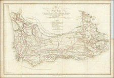
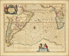
The present example was acquired in a group of 10 charts, which had been mounted back to back for use at sea. All of the other charts named Johannes Loots as the maker, including a second chart which covered a broader region of the southwestern coastline of Africa, with a large inset of the west coast of South Africa: /gallery/detail/26875 . Given Scholte's dating of the chart, its appearance in this group of maps and the similarity in the engraving styles, we think that it is very likely that the chart was published by Johannes Loots (the world map in the group was also a land map--the rest were sea charts).
Johannes Loots (1665 - 1726) was a publisher of sea charts who was active from the 1693 until his death in 1726. Loots began his career as an apprentice to Hendrick Doncker and later set up his own shop on Nieuwebrugsteeg in Amsterdam, in 1693. Between 1695 and 1698, Loots, Claes de Vries (a surveyor-cartographer) and Antoni de Winter (an engraver) entered into a joint venture to produce 200 sea charts on a Mercator Projection (Van Keulen Cartography, p 46). The plans were advertised in the Amsterdamsche Courant in August and October 1698 and several charts offered separately. However, the venture only produced 120 charts (Van Keulen Cartography, p. 47), and the partnership dissolved in 1707, with Claas de Vries selling at least 17 charts, including 16 large plates of the English Channel and a smaller plate of the Hull River, to Gerard Van Keulen on September 24, 1707 for 374 guilders) (Van Keulen Cartography, p. 16).
In 1707, Loots sold 100 charts on a Mercator Projection to Gerard Van Keulen. In 1707, Loots would appear to have purchased the plates of Jacob Robijn, which included the charts originally engraved by Arent Roggeveen for his Burnng Fen. These include a rare set of charts of the North American and Caribbean Coastlines, which were a significant improvement over the contemporary sea charts issued by Van Loon and Goos (for whom Roggeveen had originally made the charts).
At some point, Loots or his widow must have re-acquired the plates, as Loots' widow and her brother, Isaac Swigerts, continued to publish later editions of some of the charts until 1750, when Swigerts,sold the remainder of the Loots charts to Johannes Van Keulen II. These plates were re-engraved to include the Van Keulen name thereafter. At the time of his death, the inventory notes The inventory of Isaac Swigters estate includes 10,816 various maps, presumably, his unsold inventory.
During the life of Loots sea charts, it is known that some of the charts were copied by both Seller and Grierson.
While an inventory of Loots shop included 464 copper plates, the number of plates known to have been published by Loots is far fewer and it would appear that this inventory included multi-plate charts and non-cartographic material.
Loots' charts are extremely rare on the market. In 2011, when we acquired a group of approximately 10 charts and chart fragments from a small working atlas of Loots, AMPR recorded total of only 5 records of Loots charts offered for sale at auction or dealer catalogues in the prior 30 years.
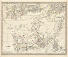
![[ Cape of Good Hope / Cape Town, South Africa ] The Dutch Colony of the Cape of Good Hope by L.S. De La Rochette MDCC XCV](https://storage.googleapis.com/raremaps/img/small/96510.jpg)