This item has been sold, but you can enter your email address to be notified if another example becomes available.


|
||

|

|
|

|
Stock# 26727
Description
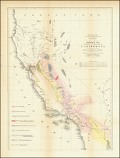
Detailed map of the Central Part of California, focusing on the various oil regions of the San Joaquin Valley.
The map is corrected to 1927 and shows a list of Prospect Wells, Producing Areas, Pipe Lines, County Roads and Railroads.
A scarce privately printed map focusing on the California petroleum industry.
Condition Description
Some staining and discoloration
![(Mexican War) [ Proposed United States - Mexico Military Border - January 1848 ]](https://storage.googleapis.com/raremaps/img/small/99246.jpg)