This item has been sold, but you can enter your email address to be notified if another example becomes available.


|
||

|

|
|

|
Stock# 26726
Description
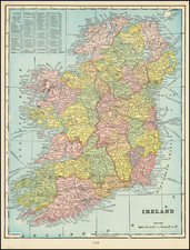
Large and highly detailed map of Ireland, hand colored by counties.
Shows towns, railways, canals, rivers, lakes, coastal details, shipping routes, etc. Decorative piano key border.
Scarce full color example, from Johnston's National Atlas.
Condition Description
A bit of marginal soiling.
![[Hungarian Map of Great Britain] Nagy Britannia](https://storage.googleapis.com/raremaps/img/small/85219.jpg)

![[ World Atlas ] Geography Anatomized: or, A Compleat Geographical Grammer. Being a Short and Exact Analysis of the whole Body of Modern Geography... To which is subjoin'd the present State of the European Plantations in the East and West Indies, with a Reasonable Proposal for the Propagation of the Blessed Gospel in all Pagan Countries.](https://storage.googleapis.com/raremaps/img/small/85550.jpg)