|
||

|

|
|

|
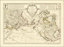
A striking map of The United States and Canada, with excellent focus on the western United States and Canada, including a revised and updated NW Coast, which incorporates the discoveries of the Russians in the 1750s and eliminates the mythical Bay of the West and other imaginary cartography from the mythical discoveries of Admiral De Font. The map instead illustrates the mythical great rivers of the West, one extending from the Puget Sound area (Aguilar's Entre) to Lake Winnepeg and then on to Hudson Bay in a series of waterways. The second extending from San Francisco Bay to the Rockies, traversing a mythical mountain range. A decorative map with marvelous western cartography. A bit of discoloration at the fold, which is the norm for this map.
Louis Brion de la Tour (ca. 1743-1803) was a French geographer and demographer. Little is known about Louis’ early life, but some glimpses of his professional life survive. He did achieve the title of Ingénieur Géographe du Roi. Much of his work was done in partnership with Louis Charles Desnos, who was bookseller and geographical engineer for globes to the Danish Crown. He worked on the Indicateur fidèle ou guide des voyageurs, qui enseigne toutes les routes royales between 1762 and 1785. During his career he also worked on several atlases. By 1795, he had gained a pension from the National Assembly. Perhaps this pension was granted in part because his son, also Louis Brion de la Tour (1763-1823), was an engraver who made Revolutionary prints, as well as maps.
![[ Sir Edmund Halley's Observations on the Variation of the Compass ] A New and Correct Chart of the Western and Southern Oceans Shewing the Variations of the Compass According to the latest and best Observations [with text:] The Description and Uses Of A New and Correct Sea-Chart of the Western and Southern Ocean, Shewing the Variation of the Compass](https://storage.googleapis.com/raremaps/img/small/98400.jpg)