|
||

|

|
|

|
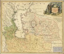
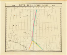
Very rare map first published by Hessel Geritsz, showing the search for the Northeastern passage, based upon the work of Isaac Massa and later included by de Bry in his tenth part of his Petit Voyages.
Isaac Massa (1586-1643) was born to a wealthy silk trading family. In 1601, Isaac left Haarlem for Moscow to assist the family trade. In 1612-1613 Massa published two articles on Russian events and the geography of the Land of Samoyeds, accompanied with a map of Russia, in an almanac edited by Hessel Gerritsz (see below). His notes on his various travels have been published in conjunction with maps by Henry Hudson.
Massa's writing was based on an underlying concept of indispensable punishment for sins. Godunov, False Dimitri and the nation itself all paid for their mortal sins (Massa was confident that Godunov killed Feodor I and the real Tsarevich Dimitri). Russian sources consider him the least biased of contemporary Western witnesses, and a very well informed one (his contemporary, Jacob De la Gardie, characterized Massa as "extremely artful in learning other people's secrets").
Massa is credited with five published maps of Russia and its provinces, the last ones compiled around 1633, and two maps of Moscow city, including the schematic account of the 1606 battle between Vasily Shuysky and Ivan Bolotnikov's armies. Retrieving original muscovite maps could have been dangerous for Massa himself and fatal for his Russian sources. Massa's rendition of the Siberian coast represented an advance in geography and for decades remained the only map of this region. It was subsequently copied by Mercator and Hondius, Jan Janssonius and Willem Blaeu.
Hessel Gerritsz published his Beschryvinghe vander Samoyeden Landt in Tartaryen, including some very informative maps of the northern parts of Europe and America. The book became very popular and it appeared in six editions in 1612 and 1613.
Hessel Geritsz was Plancius' successor as official cartographer to the VOC (Dutch East India Company).
Theodor de Bry (1528-1598) was a prominent Flemish engraver and publisher best known for his engravings of the New World. Born in Liege, de Bry hailed from the portion of Flanders then controlled by Spain. The de Brys were a family of jewelers and engravers, and young Theodor was trained in those artisanal trades.
As a Lutheran, however, his life and livelihood were threatened when the Spanish Inquisition cracked down on non-Catholics. De Bry was banished and his goods seized in 1570. He fled to Strasbourg, where he studied under the Huguenot engraver Etienne Delaune. He also traveled to Antwerp, London, and Frankfurt, where he settled with his family.
In 1590, de Bry began to publish his Les Grands Voyages, which would eventually stretch to thirty volumes released by de Bry and his two sons. The volumes contained not only important engraved images of the New World, the first many had seen of the geographic novelties, but also several important maps. He also published a collection focused on India Orientalis. Les Grands Voyages was published in German, Latin, French, and English, extending de Bry’s fame and his view of the New World.