|
||

|

|
|

|
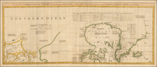
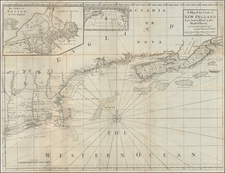
Nice example of Cornelis Wytfliet's map of the Central part of North Ameic, from Wytfliet's Descriptionis Ptolemaicae Augmentum, the first atlas to focus on the mapping of the New World.
This is perhaps the most enigmatic of Wytfliet's maps, as it covers a region virtually unknown to Europeans at the time of the map's creation. As noted by Burden:
. . . Wytfliet showed every part of the continent howver little knowledge there was of it. This is, however, the first map of present day central Canada. The basic cartography is derived from Gerard Mercator's world map of 1569, which first depicted a large body of water inland in the extreme north. There has been speculation as to what this might refer to; it has been suggested that it could be a record of a voyage unknown to us that visited Hudson Bay. , it could even be the remnants of the Verrazzano Sea theory. At the top of the map we find the Northwest Passage. . . Some sense of the extent of the map can be seen by the incorporation of the Septem civitates of the southwest, and Hochelaga, or Montreal in the east.
While Burden calls the map a map of Central Canada, his last sentence above reflects the true scope of the map, which in fact covers most of the central part of North America, from the American Southwest, Montana, Wyoming, Utah, Colorado, Alberta and parts to the north, to the Midwest, Great Lakes and contingous northern parts of Canada. The region shown at the bottom of the map is Nova Granada, and the maps coordinates place it more or less directly north of Wytfliet's Grantaa Nova et California, with the 7 Cities of Cibola (Septem civitates), the legendary Golden Cities of the American Southwest, showng at the bottom of the map, at what is probably the northern tip of the Rio Grande. The center of the map would therfore likely include the modern Midwest & Great Lakes region, with the region identified as Tolm Regnum is the eastern extension of the Tolm Regnum which appears on Wytfliet's map of the Northwest & Alaska ( Limnes Occidentis Quivira et Anian) , which would place the Tolm Regnum in the general vicinity of Utah, Wyoming, Montana and contiguous parts of Canada.
While the region covered is virtually entirely myth and speculation, the map is probably best described as the first modern map to cover the Central parts of the United States and Canada, including the northeastern portions of the Transmississippi West.
In 1597 Cornelis van Wytfliet published his Augmentum to Ptolemy's Geography. The purpose was to provide a systematic description ofl the Americas, a part of the world unknown to Ptolemy. Wytfliet dedicates his work to Philip III of Spain. The book is a history of the New World to date, recording its discovery, natural history etc. Wytfliet includes nineteen maps, one of the world and eighteen regional maps of the Americas, the first "Atlas" to focus on America.
The present example of the map is state 3, with the corrected spelling of Higuater, which had been spelled Hignater on the prior two editions of the map.
Cornelius de Wytfliet (ca.1550-ca. 1597) was a Flemish cartographer most famous for his Descriptionis Ptolemaicae Augmentum. The work was published in Louvain, Belgium, and had nineteen maps of the Americas.