
This item has been sold, but you can enter your email address to be notified if another example becomes available.


|
||

|

|
|

|
Stock# 26656
Description
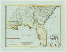
A nice example of this large format map of Florida, showing the extent of the surveys in the state of Florida.
Shows extensive detail throughout Florida, including towns, forts, lakes, rivers, the Arredondo Grant, swamps, light houses, landings, etc. Ft. Dalles appears, but not Miami.
This is the first edition to included the Florida Keys. Approved by John Wescott, Surveyor General, October 31, 1854.
Condition Description
Minor discoloration along several folds, as usual.


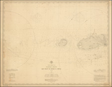
![[Untitled Coast chart of North Carolina, South Carolina, Georgia, and Florida, with insets of the harbor of Charleston, S.C. and the entrance of the Saint Johns River]](https://storage.googleapis.com/raremaps/img/small/91737.jpg)