|
||

|

|
|

|
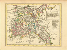
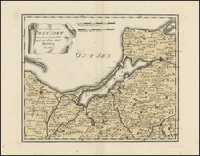
Striking map of Prussian, extending from thPomerelie and the Golfe of Dantzick in the west to Samogitie and Sclavonie in the east, tracking the Mimmel River and extending north to Memmel and just beyond. A remarkabley detailed map, showing hundreds of towns, rivers, mountains, lakes, forests, castles, principalities and a host of other details. Attractive title cartouche. A flawless example of Scarce Remondini's edition of Santini's map of Prussia. Wide clean margins and a fresh dark image.
Paolo Santini (1729-1793) was an Venetian engraver known especially for his religious prints and fine cartographic engravings. He published in Venice and may have a been a member of the clergy. In his maps, he largely adopted and adapted the work of his French counterparts, especially the brothers de Vaugondy.
![Europae Tabula VIII [Russia, Baltic, Scandinavia]](https://storage.googleapis.com/raremaps/img/small/94884.jpg)