
This item has been sold, but you can enter your email address to be notified if another example becomes available.


|
||

|

|
|

|
Stock# 2662
Description
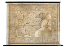
Interesting map of the United States, hand colored by State. The most notable features of the map are in the West, where the so-called projected states of Idaho, Montana, Dacotah and Wyoming are shown, each with an odd, although remotely accurate configuration. The former Baylor Line (Arizona below New Mexico) is shown in the wash coloring. Nevada is oddly misshaped and truncated at the bottom and Utah is still in its earliest configuration, prior to losing territory to Nevada. Railroads and early roads are shown, along with towns, mountains, rivers, lakes, Indian Tribes, etc.
![Vereinigte Staaten Von Nordamerika [United States of North America]](https://storage.googleapis.com/raremaps/img/small/92015.jpg)
![United States of America [with] The Course of the River St. Laurence from Lake Ontarion to Manicouagan Point](https://storage.googleapis.com/raremaps/img/small/71643.jpg)
![[ Missouri named State of Jefferson ] Etats-Unis par A.M. Perrot](https://storage.googleapis.com/raremaps/img/small/99019.jpg)
![[United States]](https://storage.googleapis.com/raremaps/img/small/93852.jpg)
![[HAPAG Map of the United States and Canada]](https://storage.googleapis.com/raremaps/img/small/78779.jpg)