|
||

|

|
|

|
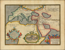
Decorative large format double hemisphere map of the World, dedicated the Charles III, King Roy des Espanges, featuring several of the great cartographic myths of the second half of the 18th Century.
Desnos' map provides a noteworthy large format presentation of the world as known on the eve of Captain James Cook's first voyage (1768 to 1771), which would significantly re-draw significant portions of this information shown on this map. Desnos' includes a fine combination of up to date cartographic information and the routes of important 18th Century voyages of exploration, along with several of the great cartographic myths and misconceptions. In the area of Alaska and the Northwest, a massive Bay of the West is shown, along with a continuous river to its north, both of which result in an as yet undiscovered Northwest Passage. A third water course, to the north, labeled Lac Falasco is equally unusual. A massive tentatively known land mass is shown, the lower portion of which corresponds loosely with the Aleutian Archipelago, but to the north, the coastline running east and west at 75 degrees and labeled "Terres decouverte par les Russes" (land discovered by the Russians) is complete fantasy.
Several annotations confidently state the discoveries of Juan de la Fuca in 1592 and D'Aguilar in 1603, along with the mythical reports of Admiral de Fonte. By contrast, the discoveries of Tchirkow, von Strahlenberg and De L'Isle de la Croyere accurately document the Russian explorations in the region are noted, with the first Russian explorations in the region dated 1731. The explorations of the French Captain Nicholas de Frondat are shown. Frondat, who was captain of the Saint Antoine, had gone as far as China and Japan to trade. On his way back, following a northern route, even more northern than the route taken by the Manila Galleon, he was able to observe the islands off California, as stated in his logbook, the first Frenchman to make this route.
To the south, in the Pacific, the routes of Anson, Magellan, and Le Maire & Schouten are shown, tracking from the Chilean Coast to Southeast Asia, after crossing from the Atlantic to the Pacific. In the South Atlantic, the route of the French explorer Jean-Baptiste Charles Bouvet de Lozier is shown. Bouvet left France in 1738, with the intent of making discoveries in the so-called South Seas which could accomodate French trading vessels enroute to Asia. He is credited with the discovering the Cape of Circumcision (Bouvet Island), although he fell considerably short of the Antarctic Coastline he sought. The map shows the icebergs and lands spotted by Bouvet in December 1738 and January 1739.
To the east, the western and northern coastlines of Australia are largely (if not accurately) charted, although the myth of showing New Guinea connected to Australia, to the north of the area labeled Carpentaria is still shown. Only the west coast of New Zealand is shown, just a few years before Cook's arrival. This portion of the map would be completely redrawn, following Cook's return in 1771.
Desnos's map is richly embellisehd with allegorical figures showing the 4 continents as female figures (Asia top left, Europe top right, America bottom left, Africa top right), along with representative scenes from each of the 4 continents. Along the top are models showing the moon based upon Cassini's model, a Copernican model of the solar system, a model of the sun based upon Athaneus Kircher, Jupiter and Saturn with their moons, based upon Cassini, along with Mars, Mercury and Venus. A portait Charles III and other decorative features complete the map.
A fascinating blend of fact and myth, science and allegory. The map is quite scarce on the market, with AMPR showing only 2 examples offered in 1991 and 1994.
![(Second World War) Newsmap -- Monday, November 23, 1942 [on verso:] Life Save #2 Winning Friends - Helping People](https://storage.googleapis.com/raremaps/img/small/94937.jpg)
![Hemisphere Septentrional du Globe Terrestre Veu en concave l'oeil estant au Pole AntArctique . . . 1696 [and] Hemisphere Superieur du Globe Terreste pour l'Horizon de Paris Veu en convexe l'oeil etant pose au zenith et a distance infinie du plan de projection . . . 1697](https://storage.googleapis.com/raremaps/img/small/85541.jpg)