


|
||

|

|
|

|
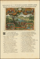
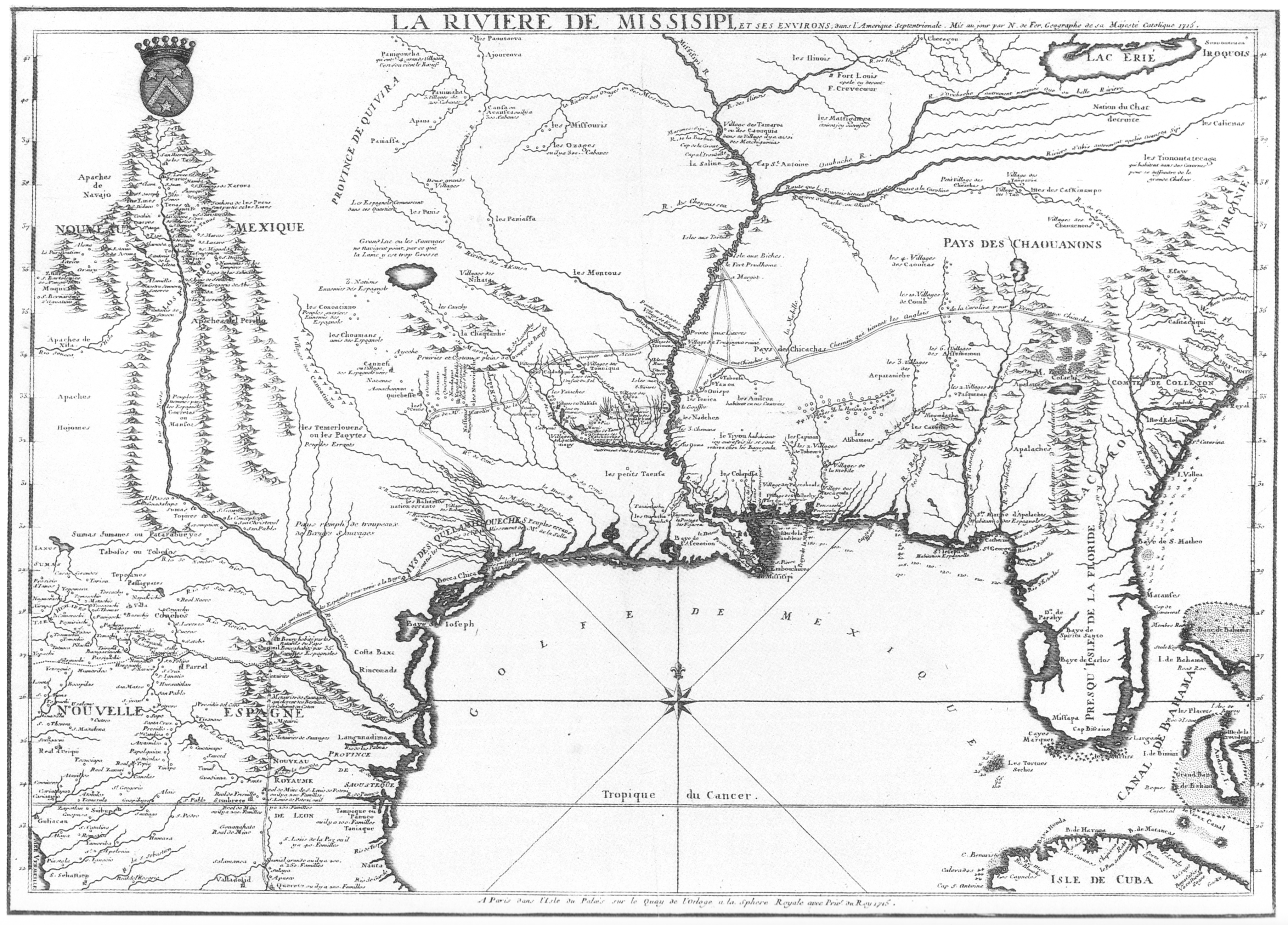
Fine example of De Fer's rare 2-sheet map of the French regions in North America, prepared for the French Company of the West (John Law & the Mississippi Bubble), one of the most important maps of the region and one of the earliest maps to incorporate the reports of Jesuit missionaries and explorers activein the early 18th Century.
De Fer's map is perhaps the most important and influential regional map of the period, providing significantly updated cartographic information in a number of regions. The map is the first printed map to provide the updated treatment of the Mississippi River later made famous by De L'Isle in his Carte de la Louisiane et du cours du Missisipi. . . (pre-dating De L'Isle's map) , the first to include the updated information along the Gulf Coast transmitted to France by Francoise Le Maire and the first to incorporate the revised and improved mapping of the Great Lakes derived from Jesuit missionary sources in the north.
While its cartographic details rival the contemporary maps of Guillaume De L'Isle for primacy, De Fer's map was almost certainly the more influential work at the time it was published, having been commissioned by John Law's Compagnie d'Occident (Company of the West), to provide a graphic depiction of the vast and rich commerical potential of French Louisiana, for which commercial rights had just been ceded to Law's Company of the West.
De Fer first began work on his map in 1715, when he issued his La Riviere de Missisipi, et ses Environs, dans l'Amerique Septentrionale ..., based upon a 1701 manuscript map by Guillaume De L'Isle. rla.unc.edu/Mapfiles/misc/Fer%201715.BRA.Elkhadem.jpg . The 1715 map is essentially the proof state for the lower half of the 2-sheet map, lacking the internal embellishments intended to demonstrate the wealth of the region. With the founding of John Law's Company of the West and Law's being granted by the King of France the rights to commercial control of Louisiana in August 1717, Law commenced an advertisting and promotional campaign to attract investors for his new company. A visual tool was undoubtedly needed to help potential investors understand the scope and commercial potential of France's holdings in Louisiana. To fill the need, De Fer was commissioned to create such a map.
De Fer's map, which bears the "Armes de la Compagnie," states in the title "jusques en 1717 qui est l'annee de l'etablissement de la compagnie d'occident et pour laquelle cette carte a ete dressee. . . " (1717 is the year of the establishment of the Compagnie d'Occident and the reason this map was drawn up). While the 1715 map had been quite plain in its depiction of the the southern regions, the 1718 edition is expanded to include the Upper Mississippi and Great Lakes, and lavishly embellished with vignettes highlighting the rich hunting grounds, fur trade and ample watercourses which could be found in the region, undoubtedly to persuade potential investors of the commercial potential of the region and Law's enterprise.
Utilizing the most recent infomation transitted back to France by Jesuit Missionary Francoise Le Maire and others, De Fer updated his 1715 map and added a second sheet to the north, bearing the title " Le Cours du Missisipi, ou de St. Louis Fameuse Riviere de l'Amerique Septentrionale. . . " Later, De Fer added two additional half sheets to the east, completing a 4 sheet wall map which depicted the rest of the Colonies. De Fer's map was immediately copied by Gerard Van Keulen in 4 sheets ( Carte de la Nouvelle France ou se Voit le Cours des Grandes Rivieres de S. Laurens & de Mississipi Aujour d'hui S. Louis, aux Environs), and was also reproduced in single sheet versions by Chatelain and Ottens ( Carte de la Nouvelle France, ou se Voit le Cours des Grandes Rivieres de S. Laurens & de Mississipi).
De Fer's map was of great contemporary importance. Among its most important features, it is the first printed map to depict Francoise Le Maire's manuscript copies of the best available Spanish manuscript charts, including the Enriquez Barroto - Bisente manuscript charts of the Gulf Coast (the large inset at the top of the map), which significantly improved the cartographic details of of the Gulf Coast and its principal Bays. Henry Popple would later utilize De Fer's map to delineate Spanish settlements on the Rio Grande and territory west of the Mississippi Valley. De Fer's Great Lakes model was utilized well into the 18th Century, most notably serving as the model for the first edition of John Mitchell's monumental map of North America. Perhaps of greatest historical significance, it was undoubtedly a very useful selling tool for John Law, helping him raise significant sums of money for his venture, which would later end with a massive commercial failure known as the Mississippi Bubble.
The map provides credits to some of the most important French explorers and missionaries in America in the late 17th and early 18th Centuries, whose work is incorporated in the map, including Hennepin, de La Salle, Tonti, Justel, des Hayes, and Jolliet. Perhaps most notable is the contributions of Francois le Maire, a Jesuit Missionary in Louisiana, whose job from 1706 to 1720 included the review and transcription of explorers' journals, accounts (and maps), which were recorded in his memoirs and then transmitted back to France. Many of these reports and maps were obtained from Spanish sources. One noteworthy example of the Spanish source maps utilized by Le Maire is a manuscript chart illustrated by Jackson in Flags Along The Coast (opposite page 59) and attributed to "a [Spanish] pilot named Soupar (or Soupart)." As noted by Jackson (p. 60):
Francois Le Maire arrived in [Louisiana] in 1706 and devoted himself to a study of its geography. Le Maire collected the accounts of various explorers, analyzed the data, and then forwarded them to France in the form of memoirs and maps. Le Maire's work enabled De L'Isle to produce one of the most influential maps of North America ever made, his 1718 Carte de la Louisiane et du cours du Missisipi.
The large inset at the top of De Fer's map is an almost exact copy of the Soupar / Le Maire chart ( Carte de la Cote de La Louisiane depuis la Cote-de Ouest de la Floride iusqu'a l'Ouest de la Riviere du Missisipy par moy Sovpar 1716), with two noteable exceptions, the shape of Pensacola Bay and the shape of the "Baye de Ste. Rose," to the east. For these two features, De Fer's map more closely resembles a manuscript map by Valentin Devin, entitled Carte de la cote de la Louisiane, depuis l'Embouchure de Mississipi . . . . , which states that it was prepared based upon the observations of M. de Serigny in 1719 and 1720. The Devin map, illustrated as plate 27 in Flags Along The Coast, provides a nearly identical model for De Fer's "Baye de Ste. Rose," but its treatment of Pensacola Bay is very different, as its treatment of the course of the Lower Mississippi, Lake Ponchartrain and other parts of the map.
Examples of the two sheet map are extremely rare, with the only illustrated example that we could locate in the collection of the Newberry Library: www.library.illinois.edu/contentdm/cdm4/item_viewer.php?CISOROOT=/maps&CISOPTR=2275&CISOBOX=1&REC=2 . The 2 eastern sheets (not present here) appear to have been hastily created after the completion of the northwestern sheet, as the engraver seems to have made a significant error in the scale of the 2 eastern sheets map, placing Lake Ontario and 3 of the rivers a full degree to far north, causing the engraving of the Lake and the 3 rivers to veer abruptly south, in order to meet up with the northwestern sheet. We are aware of only 2 examples of the De Fer's map on the market in the past 30 years.
A fine example of one of the most important commercial and cartographic works of the early 18th Century.
Nicholas de Fer (1646-1720) was the son of a map seller, Antoine de Fer, and grew to be one of the most well-known mapmakers in France in the seventeenth century. He was apprenticed at twelve years old to Louis Spirinx, an engraver. When his father died in 1673, Nicholas helped his mother run the business until 1687, when he became the sole proprietor.
His earliest known work is a map of the Canal of Languedoc in 1669, while some of his earliest engravings are in the revised edition of Methode pour Apprendre Facilement la Geographie (1685). In 1697, he published his first world atlas. Perhaps his most famous map is his wall map of America, published in 1698, with its celebrated beaver scene (engraved by Hendrick van Loon, designed by Nicolas Guerard). After his death in 1720, the business passed to his sons-in-law, Guillaume Danet and Jacques-Francois Benard.
![[ Upper California, Texas and Mexico ] Carte Generale Du Mexique Ed Des Provinces-unies De L'Amerique Central ou Guatemala](https://storage.googleapis.com/raremaps/img/small/81604.jpg)
![Map of Texas [with] inset of N.W. Part of Texas](https://storage.googleapis.com/raremaps/img/small/84519.jpg)