The item illustrated and described below is sold, but we
have another example in stock. To view the example which
is currently being offered for sale, click the
"View Details" button below.
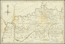
1796 Jedidiah Morse
$ 750.00


|
||

|

|
|

|
Stock# 26530
Description
One of the earliset maps of Tennessee and Kentucky printed in the United States and one of the earliest obtainable maps of each of these states.
The map was engraved by Amos Doolittle, one of the most important 18th Century American engravers. Among the more interesting features of the map are the detailed treatment of the early roads in the region. The map shows military reservation boundaries, Indian boundaries, early towns, roads, rivers, mountains, lakes, Indian Villages, counties and a host of other details.
The map appeared in Jedidiah Morse's American Univeral Geography.
Reference
Wheat & Brun 645


![[Hand Drawn Map] Le Golfe de Mexique avec les Pays Circonvoisins](https://storage.googleapis.com/raremaps/img/small/91580.jpg)
![[ Extensively Annotated By An Early Owner ] Georgia from the latest Authorities](https://storage.googleapis.com/raremaps/img/small/100877.jpg)