![[ Mount Athos / Alexander the Great ] Nomen idem, at maior virtus, facit ausibus artem By Francois Spierre](https://storage.googleapis.com/raremaps/img/small/64701.jpg)


|
||

|

|
|

|
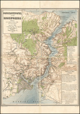
Fine example of this spectacular view of of the Dardenelles, with Constantinople in the distance.
The view shows Chateau Neuf 'd Asie and Chateau Neuf d' Europe in the foreground, with a naval battle ongoing, symbolic of the Ottoman control of the Straits from both sides of the Dardenelles. Additonal fortifications are shown opposite Gallipoli. Constantinople, Mont Ida, the Golf of Nizza and Sea of Marmara are also noted.
The view highlights the fine engraving style which typifies De Fer's work during this period. The precision and detail of this work are of the highest quality. While this work is unsigned, it is known that De Fer engaged a number of master engravers for his Atlas Curieux.
Nicholas de Fer (1646-1720) was the son of a map seller, Antoine de Fer, and grew to be one of the most well-known mapmakers in France in the seventeenth century. He was apprenticed at twelve years old to Louis Spirinx, an engraver. When his father died in 1673, Nicholas helped his mother run the business until 1687, when he became the sole proprietor.
His earliest known work is a map of the Canal of Languedoc in 1669, while some of his earliest engravings are in the revised edition of Methode pour Apprendre Facilement la Geographie (1685). In 1697, he published his first world atlas. Perhaps his most famous map is his wall map of America, published in 1698, with its celebrated beaver scene (engraved by Hendrick van Loon, designed by Nicolas Guerard). After his death in 1720, the business passed to his sons-in-law, Guillaume Danet and Jacques-Francois Benard.
![[ Greece ]. Neuw Griechenlandt mit andern anstossenden Landern / wie es zu unsern zeiten beschribenist](https://storage.googleapis.com/raremaps/img/small/80551.jpg)
![[ Cyprus, Syria, Palestine, etc. ]](https://storage.googleapis.com/raremaps/img/small/103027.jpg)