


|
||

|

|
|

|
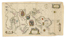
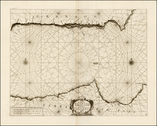
Previously unknown proof state of De Wit's important sea chart of Europe, likely printed between 1710 and 1715, in full original color, with fine wide margins.
A beautiful Dutch Portolan style sea chart that shows an area from Morocco to the Scandinavian island of Spitsbergen and Iceland. The map extends west to east from Iceland to Dalmatia and north to south from Spitzbergen to Morocco, continuation Chart of the Mediterranean inset to Africa, several decorative crests, numerous rhumb lines, vignette depictions of Elephants in North Africa and rutting Goats in Norway. The inset map on the left shows the continuation of the Mediterranean. Richly embellished with three scales and one title cartouche, two pairs of animals, goats in Scandinavia and elephants in Africa. Winged putti holding navigational instruments surround the title cartouche.
The chart was first issued by De Wit circa 1675, and included elaborate coats of arms. In this rare proof state, the coats of arms have been removed and the interior regions re-engraved. Our investigation of the map includes correspondence with Dr. George Carhart, who reports that this state of the map is similar to an example in a 150 map De Wit Atlas in the Hungarian State Library, but notes that this copy lacks the De Wit imprint on the HSL copy. Dr. Carhart concluded that this edition was therefore either a proof created by De Wit's widow or Louis Renard, prior to Renard's publication of the first edition of his atlas, which includes a copy of the map with Renard's imprint. Dr. Carhart also notes De Wit was editing his charts just before his death and that his wife likely continued the process until the plates were sold to Renard in 1710.
A fine dark impression in flawless old color.
De Wit (1629 ca.-1706) was a mapmaker and mapseller who was born in Gouda but who worked and died in Amsterdam. He moved to the city in 1648, where he opened a printing operation under the name of The Three Crabs; later, he changed the name of his shop to The White Chart. From the 1660s onward, he published atlases with a variety of maps; he is best known for these atlases and his Dutch town maps. After Frederik’s death in 1706, his wife Maria ran the shop for four years before selling it. Their son, Franciscus, was a stockfish merchant and had no interest in the map shop. At the auction to liquidate the de Wit stock, most of the plates went to Pieter Mortier, whose firm eventually became Covens & Mortier, one of the biggest cartography houses of the eighteenth century.
![[ Map of Modern Europe in Faces ] Карта современной Европы въ лицаx](https://storage.googleapis.com/raremaps/img/small/98887.jpg)
![(Second World War - Prelude to War) Die Luftbedrohung Deutschlands [The Air Threat to Germany]](https://storage.googleapis.com/raremaps/img/small/84075.jpg)