


|
||

|

|
|

|
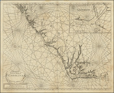
Rare early sea chart of the Carolina coastline, from Cape Charles to the area around Hilton Head, published by Thornton.
The chart is oriented with east at the top of the map and includes an inset map of the Ashley & Cooper Rivers, centered on Charles Towne (Charleston). As noted by William Cumming:
The most important chart to the maritime traders and colonizers of North Carolina was " A New Mapp of Carolina By John Thornton ... and Will: Fisher," published in 1689 in the Fourth Book of the English Pilot. Unfortunately, it was full of errors and inaccuracies-unfortunate, because The English Pilot was the Bible of English mariners; and the Fourth Book, of prime importance in the history of American cartography, contained the first great collection of charts of British (not Dutch or German) origin delineating the coast of America. Many of its American coastal charts were repeatedly and extensively revised, but the Carolina map was reprinted and even reengraved without improvement. Its inaccuracies were very dangerous to attempted navigation in those waters: its "Corituck" and "New Inlet" were inlets not usable . . . "Roanoke Inlet" was erroneously put opposite Colleton Island and called "Old Inlet," and Roanoke Island itself was portrayed as a small islet hugging the mainland shore. Cape Lookout was shown as barely a protuberance, with shoal water, along the Outer Banks; and the only settlements noted were "Capt. Willobies P.ta" on Currituck Sound and "Charles Town," a temporary and soon abandoned settlement of the 1660's on the Cape Fear River.
A map of primary importance for Carolina Collectors.
The erasure of the imprint occurred in the 1728 edition, dating this example to that edition or later.
John Thornton was a respected and prominent chartmaker in London in the latter part of the seventeenth century. He was one of the final members of the Thames School of chartmakers and served as the hydrographer to the Hudson's Bay Company and the East India Company. He produced a large variety of printed charts, maps, and atlases in his career, but he was also a renowned manuscript chart maker. Born in London in 1641, he was apprenticed in the Drapers Company to a chartmaker, John Burston. After being made free of the company (1665), he was part of the combine that took over John Seller’ English Pilot in 1677. Thornton was trusted by the naval and navigational establishment of the day; one of his clients was Samuel Pepys, naval administrator and diarist. Thornton died in 1708, leaving his stock to his son, Samuel, who carried on the business.
Samuel, born in ca. 1665, also had apprenticed in the Drapers Company and was made free a year after his father’s death. He continued the business until 1715, when he died. His stock then passed to Richard Mount and Thomas Page.

![(Carolinas) Virginiae Partis australis, et Floridae partis orientalis, interjacentiumqus regionum Nova Descriptio [A New Description of the Southern Part of Virginia and the Eastern Part of Florida, and the Intervening Regions.]](https://storage.googleapis.com/raremaps/img/small/94131.jpg)