|
||

|

|
|

|
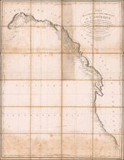
Landmark American Map of the Coast of Nova Scotia
Important 2 sheet map of the coast of Nova Scotia, one of the earliest sea charts of the region printed in America.
Norman's chart shows the Atlantic coast of Nova Scotia from Cape Sable to Forked Harbor on Cape Breton. In the upper right is a portion of the Bay of Fundy. There are two perspective views of the approach to Halifax in the central left portion of the image, "Appearance of Chebudo Head..." and "Appearance of Lighthouse Island... ." The map is exceptionally detailed for the period, with a wonderful primitive engraving style indicative of 18th Century American printing.
Following shortly after Matthew Clark's impossibly rare map of the region, John Norman's chart of the Maine Coastline was the first printed chart of the region and the best available chart of this area in the early years of the United States. Because of its use at sea, Norman's map is now of extreme rarity. Offered here is the especially rare second state of Norman's chart, which appeared only in the 1803 edition of the American Pilot. The primary difference between the maps is the addition of the title in the second state.
The American Revolution brought an end to Britain's leading role in the mapping of America. The task now fell to the American publishing industry, still in its infancy, but with direct access to new surveys that were documenting the rapid growth of the nation. In particular, there was a need for nautical charts for use by the expanding New England commercial fleets. The first American marine atlas, Matthew Clark's A Complete Set of Charts of the Coast of America, was published in Boston in 1790.
In 1791 John Norman of Boston first published The American Pilot, containing the navigation of the sea coast of North America.... Norman's Pilot was the second sea atlas published in America, the first being by William Clark, published in 1789-1790. (Norman also had a part in Clark's "Pilot," as he was the engraver for a majority of the charts. In 1794, William Norman appeared as the publisher of this Pilot, taking over from John Norman.
![[The First Maps Printed Color] Cartes en Couleur des Lieux Sujets aux tremblements de Terre Dans toutes les parties du Monde Selon le Sisteme de l’impulsion Solaire](https://storage.googleapis.com/raremaps/img/small/52293op.jpg)