|
||

|

|
|

|
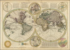
The 1650 Berey map is the earliest known example of this map to survive. The map was reissued in 1668 by Hubert Jaillot, with decorative panels above the map showing mounted horsemen and panels of text and smaller maps around the map image, from Berey's rare world atlas.
The map was first issued in 1644. It includes a long note at the bottom of the western hemisphere discussing Brouwar's discoveries in 1643 and may be the earliest printed map to record this information. The 1644 edition was unknown until a copy appeared at auction in 2009, purchased by Barry Lawrence Rudeman Antique Maps in partnership with another dealer. This 1644 edition had a different set of Berey's smaller maps around the main map image, but did not include the horsemen.
The example illustrated here is the only known surviving example of the 1650 edition of the map, which lacks all of the panels surrounding the map. This image is taken from the BNF Library and was not offered for sale by this firm. We offer the image for reference purposes only.
![(Second World War) Newsmap -- Monday, November 23, 1942 [on verso:] Life Save #2 Winning Friends - Helping People](https://storage.googleapis.com/raremaps/img/small/94937.jpg)
![[ World Atlas ] [ Composite Atlas of the World including important American maps and Whiston's Scheme of the Solar System ]](https://storage.googleapis.com/raremaps/img/small/100165.jpg)