|
||

|

|
|

|
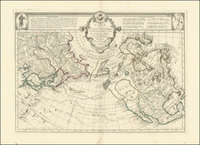
Rare Russian map of the southwest portion of Alaska, including Kodiak Island, the base of the Aleutian Peninsula, present day Anchorage, and north along the west coast to nearly the Bering Strait, prepared to illustrate the account of Baron von Wrangel during his 6 years as the head of the Russian American Company (1829-1835).
The map is exceptionally detailed and reflects some of the earliest first hand observations in the region, pre-dating the earliest detailed English, French & American Surveys in the region by several decades and including the locations of settlements, forts and other placements, some of which had not previously appeared on any printed maps.
This rare and highly detailed map appeared in the first volume of Baer & Helmersen's Beiträge zur Kenntniss des russischen Reiches... According to the Royal Geographical Society's Catalogue of 1895, Baer and Helmerson's Beitrage zur Kenntiss... consisted of 26 Volumes and was published in St. Petersburg from 1839 to 1871. The first volume, written by Russian explorer Baron Ferdinand Friedrich Georg Ludwig von Wrangel, was entitled Statistische und ehtnographische Nachrichten uber ie Russischen Besitzungen an der Nordwestkuste von Amerika, and included a single map.
Baron Von Wrangel (1797-1870), was a Russian Explorer and Naval Captain, and a member of the Russian Academy of Sciences. He was also one of the founders of the Russian Geographical Society. Beginning in 1817, Baron von Wrangel took part in a number of important Russian expeditions, beginning with Vasily Golovnin's world cruise on the ship "Kamchatka" in 1817-1819.
Wrangel led the Kolymskaya expedition in search of northern lands. He established that north of the Kolyma River and Cape Shelagsky there was an open sea, not dry land, as people thought. Together with Fyodor Matyushkin and P. Kuzmin, Wrangel described the Siberian coastline from the Indigirka River to the Kolyuchinskaya Bay in the Chukchi Sea. His expedition made valuable contributions to the study of glaciology, geomagnetics, and climatology and also collected data about natural resources and native population of that remote area.
After noticing swarms of birds flying north and questioning the native population, he determined that there must be an undiscovered island in the Arctic Ocean and started in 1820 a four year long expedition to search for it. Even though it was unsuccessful the island was later named Wrangel Island to honour him and his endeavor.
Wrangel led the Russian world voyage on the ship "Krotky" in 1825-1827. He held the post of the Chief Manager of the Russian American Company and was effectively Governor of its settlements in North America in 1829-1835. Prior to his departure for Russia's American colonies, he got married in 1829 to Elisabeth Teodora Natalia Karolina de Rossillon, daughter of Baron Wilhelm de Rossillon. Von Wrangel was the first of a series of bachelor appointees to the office of governor who had to find a wife before assuming the duties in America, the Russian American Company rules having been changed in 1829.
Wrangel later became a hugely significant figure in the Russian Empire, serving the head of the hydrographic department of the Russian Admiralty and later president of the Russian-American Company in 1840-1849 and the Minister of the Russian Navy 1855-1857.
![America [Manuscript Map Showing the Sea of the West!]](https://storage.googleapis.com/raremaps/img/small/41297dm.jpg)
![[Nome Gold Rush] Map of Seward Peninsula The Arctic Gold Fields of Alaska Showing Precinct Boundaries, Recording Offices, Post Offices, Trails & Road Houses . . . December 1903](https://storage.googleapis.com/raremaps/img/small/76156.jpg)