|
||

|

|
|

|
Fine example of this rare sea chart of the Baltic Sea (Oost Zee), by Arnold Colom, from Colom's Zee Atlas Ofte Water-Wereldt.
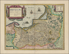
Colom's detailed sea chart of the Baltic Sea from Rügen and Denmark extending towards eastern Finland and Livland, is one of the earliest obtainable sea charts to cover this region. The chart is embellished with a large decorative allegoric title cartouche, along with a detailed inset chart of the area immediately to the east, including Livland and the neighboring Russia.
Colom's Zee Atlas is among the rarest of all folio sized Sea Atlases published in the 17th Century. Ashley Baynton Williams records 6 surviving complete examples of the atlas in his on-line essay on Colom, 5 of which are in private hands. Referring to the Zee Atlas, Koeman wrote:
This chartbook by Arnold Colom ... is one of the most important atlases in the well known category of Dutch sea-atlases. It is not the first of the group: Joannes Janssonius' Atlas Maritimus (1650), which constitutes volume 5 of the Novus Atlas opens the series ... Contrary to the rather unhomogenous set of charts by Janssonius, Arnold Colom assembled a coherent group of 15 charts, later increased to 17 plus a world map. ... Arnold Colom's three charts of the oceans are on the same scale (1:14mill.) as Portuguese and Spanish charts of that time. It marked the first time that such charts were published as atlas sheets ... (Atlantes Neerlandici, IV, p.115).
The Zee-Atlas is one of the largest format sea-atlases published in Amsterdam of the period, and also one of the scarcest. That Colom's sea atlas and his other cartographic ventures were not successful would seem to be confirmed also by the fact that Colom fell heavily in arrears with his rent. In a notarial act of 1663, Colom gave his landlord, another prominent cartographic publisher Nicolaas Visscher (II), security for the debt, which included the eighteen printing plates for the Zee-Atlas. It would appear that Colom died in 1668 without redeeming the plates, for no later editions by him are known. Visscher apparently sold the plates to Hendrick Doncker, Sr., who re-issued the plates under his own imprint in 1675. Doncker's re-issued plates are also quite rare, as Doncker soon moved on to use a smaller format set of maps for his more commercially successful atlases of the 1680s.
![(Second World War - Holocaust) Getta na ziemiach w okresie okupacji Hitlerowskiej w latach 1939-1945 | Hitlerowskie obozy prezjsciowe na ziemiach Polskich w latach 1939-1945 [Ghettos on the lands during the Nazi occupation in 1939-1945 | Nazi presiding camps in Poland in 1939-1945]](https://storage.googleapis.com/raremaps/img/small/82907.jpg)