|
||

|

|
|

|
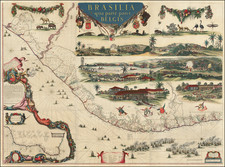
Striking full color example of the map of Brazil from Ogilby's English translation of De Nieuwe en Onbekende Wereld published by Arnold Montanus, which was used by John Ogilby as the basis of his Complete History of America.
The cartography of the region is quite primitive. West is at the top of the map, which extends from C. Nasou and Parime Lago to the Mouth of the Rio de la Plata. The early mythical cartography of the Amazon shows the source of the Amazon and the Rio de la Plata as a series of lakes called Puerto de los Reyes. The map includes two compass roses, rhumb lines, sailing ships and two large cartouches.
John Ogilby (1600-1676) was an English geographer and publisher, one of the most prominent of the seventeenth century. Little is known of his early life but by 1619 he was apprenticed to John Draper, a dancing-master in London. He worked as a dancing-master, courtier, and theater owner form 1620-1641. From 1649 he worked as a poet, translator, and publisher of classical texts. It is only in the last decade of his life that he entered into geography.
In 1649, Ogilby published his first translation, of Virgil, and continued to put out translations in the 1650s and 1660s. In March 1661 he was reconfirmed as master of revels in Ireland and appointed master of the king’s imprimeries, or king’s printer. From 1662 to 1665 he was in Ireland, where he most likely met Robert Boyle. He returned to London only to lose much of his printing stock in the Great Fire of 1666. Post-fire, he became assistant surveyor to the city, where he met Robert Hooke and Christopher Wren.
In 1669, Ogilby published Embassy to China. At the same time, he planned to release atlases that would cover the entire world. These atlases would be funded via subscriptions, advertisements, and lotteries—all common practice at the time, especially for expensive multi-volume works. He released Africa and Atlas Japannensis in 1670, America in 1671 and Atlas Chinensis in 1671, and Asia in 1673. Ogilby compiled the works based on materials produced by others and they reflect a growing interest in the wider world within England.
In 1671, while producing the atlases, Ogilby secured another royal title, that of his Majesty’s cosmographer. He used this title when publishing Britannia in 1675, his best-known work. The Britannia is best described as a road atlas; it shows 2519 miles of road in 100 strip maps. This technique would be widely adopted in the subsequent century. His method of measuring with a waywiser, a large wheel, also helped to standardize the distance of the English mile at 1760 yards. The Britannia was a major achievement in early English cartography and was republished in 1698, 1719, and 1720.
![[Ilha da Santa Catarina to Bombinhas]](https://storage.googleapis.com/raremaps/img/small/59598.jpg)
![[ Peru, Ecuador and the Upper Amazon ] Maragnony sive Amazonum Fluminis Terrarum in Orbe Maximi quo ad Hispanicae Potestai subest Cursus cum Fluvys et Regionibus finitimis Utilitati Publicae probatissimis e Documentis accuratus novissime descriptus a quodam pereas provincias olim S.I. Missinario delineatus a Petro Parcar 1785](https://storage.googleapis.com/raremaps/img/small/89253.jpg)