|
||

|

|
|

|
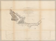
Highly detailed map of California and Nevada, with insets of the Yosemite Valley, Sacramento and SF Bay Vicinity. One of the earliest atlas maps to include and inset map of Yosemite and a plan of Sacremento. Many interesting early details, including the Coulterville Trail, Mariposa Trail and several other trails through the Valley and on the upper walls, and numerous rivers, falls, elevations and small encampments. The inset of San Francisco shows streets, parks, wharfs, rail lines and other early features. The state survey of California is nearly complete. Orange, Imperial and Riverside Counties are still not present. The primary map is one of the most detailed CA & NV maps of the period and includes early topographical details. A nice example of this increasingly rare state of Gray's map of California.
O. W. Gray was a publishing firm based in Philadelphia. Later, they published as O. W. Gray & Son. They published atlases in the late nineteenth century. Gray's National Atlas was one of the most successful commercial ventures of the 1870s and one of the last to employ hand coloring on maps.