|
||

|

|
|

|
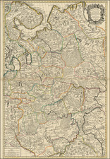
Striking map the Russian empire of Peter the Great, including conventional signs of Siberian towns, like Tobolsk, Nerchinsk, Irkutsk and Yakutsk [Iakutsk], as well as places of nomadic settlement and centers of the Khans, the headmen of the Tartars.
The arctic island Novaia Zemlia is shown with a rounded shape and Lake Baikal stretches in a east-west direction. Kamchatka is shown, but is misshapen and extends to Korea and Japan. The Great Wall of China is also shown.
Striking allegorical cartouche, showing the subjects of Russia bowing to Peter the Great, who is flanked by angels.
The Ottens brothers, Reiner and Joshua, operated a successful printing partnership in the mid-eighteenth century (fl. 1726-1765). They began the venture in 1726, publishing maps and other prints as “R & I Ottens.” They specialized in the reprinting of others’ work, especially Guillaume De L’Isle. In 1750, Reiner died; his soon, also Reiner, took his place, but the firm began listing their works as “Joshua & Reiner Ottens.” The firm lasted until Joshua’s death in 1765. Joshua’s widow, Johanna de Lindt, sold their remaining stock of plates in 1784.
![[Stop The Fake News!] Halte au Menteurs! Les Colo Bacilles Sement La Haine!](https://storage.googleapis.com/raremaps/img/small/59951.jpg)
![[Kremlin / Moscow] КРЕМЛЕНА ГРАД. Kremlenagrad, Castellum urbis Moskvae . . .](https://storage.googleapis.com/raremaps/img/small/47466.jpg)