
This item has been sold, but you can enter your email address to be notified if another example becomes available.


|
||

|

|
|

|
Stock# 25981
Description
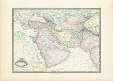
Detailed map of the Black Sea and contiguous regions, from the Allgemeiner Hand-Atlas der ganzen Erde, published in Weimar from 1796 to 1804.
The map incorporates Murdoch's projection, as do many of the maps in the atlas. Murdoch, an English mathematician active in the mid 18th Century. proposed three methods for rendering a conical projection on a map.
![Turcicum Imperium . . . [shows Cyprus]](https://storage.googleapis.com/raremaps/img/small/91206.jpg)

![[ Postal Map of Eastern Europe ] Deutschlands Postkarte begraenzt von Oesterrreich, Preussen, Frankreich, Holland, Italien und der Schweiz. Gezeichnet und Herausgegeben von Ignaz Heymann. K.K. Obserpostamtsoffizier in Trieste. 1800.](https://storage.googleapis.com/raremaps/img/small/77678.jpg)