|
||

|

|
|

|
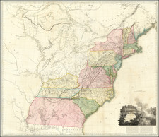
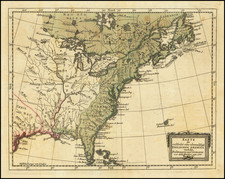
Rare old color example of John Huske's edition of the Society for Anti-Gallicans map of the British Colonies in North America, one of the most politically significant (and vitriolic) of the pre-French & Indian War propaganda maps published in London.
The Society or Order of Anti-Gallicans was organized in response to English hostilities with France in the mid-18th Century, which precipitated the Seven Years War. Officially its aims were patriotic, though they were more likely economic in nature and concerned with slowing or preventing the flow of French goods into England. Established by about the end of 1751, the Order appointed distinguished presidents, including Lord Carpenter and Sir Edward Vernon, held regular meetings, outfitted at least one privateer charged with harrying the French at sea, published patriotic songs, anti-French prints, at least one novel ( The Anti-Gallican, or the History and Adventures of Sir Henry Cobham London: 1757).
In 1755, William Herbert and Robert Sayer published A New and Accurate Map of the English Empire in North America; representing their rightful claim as confirme'd by charters and the formal surrender of their Indian friends; likewise the encroachments of the French, with the several forts they have unjustly erected therein. By a Society of Anti-Gallicans, a large, separately issued map, issued in the same year as John Mitchell's map, was a straight forward effort in British Progaganda, over-emphasizing and magnifying British claims and openly mocking the claims of the French, relegating the French to a small territory along the north shore of the St. Lawrence River between Montreal and Tadoussac, along with the north shore of Newfoundland and Prince Edward and Cape Breton.
The present map was intended to be included in John Huske's The present state of North America, &c., but was not included in most copies of the book and was apparently only available separately. It also appears In William Douglas's A summary, historical & political, of the first planting . . . & present state of the British settlements in North-America, published in London in 1760.
The last example of these books to include the map to appear at auction were in 1973 for the Huske pamphlet and 1952 for the Douglas Pamphlet.