|
||

|

|
|

|
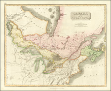
Old Color example of Abraham Bradley's map of the Midwest and Northern parts of the United States.
Abraham Bradley's map was one of the earliest maps printed in America to extend to the Mississippi River. It is also one of the few contemporary maps to identify the 5 proposed states of the Ordinance of 1789, as conceived by Thomas Jefferson.
Cincinnatus is shown. Chicago is shown, along with Detroit. A number of early forts appeare. The Land of the Six Nations is shown, as are New Connecticut, Ohio Company lands, the Seven Ranges, Ft. Knox, Ft. Vincennes, Ft. Hamilton, General Wayne's Treaty Line, Ft. Wayne, Ft. Miami, Ft. Franklin, early portages, and many notes on the regions in the west.
The present example is the second state of the map, with title word "Part" changed to "Parts."
Abraham Bradley was born in Litchfield, Connecticut. He is an important figure not only in early American cartography, but in early American history as well. Initially, Bradley trained as a lawyer and moved to the Wyoming Valley of Pennsylvania to practice. There he met Judge Thomas Pickering, who took Bradley with him to Philadelphia when he was appointed Postmaster General by George Washington in 1791.
As Pickering's clerk, Bradley created postal maps which showed the budding system of post offices and routes. A self-taught mapmaker, Bradley quickly gained considerable skill and became well-known for this carefully drawn maps. His most famous map is the postal route map of 1796, which shows the young United States and includes an innovative table that calculated the time it would take a letter to travel around the country.
In 1799, Bradley was appointed Assistant Postmaster General, a position he would hold until 1829. As part of his duties, Bradley supervised the moving of the General Post Office Department from Philadelphia to Washington DC. In 1804, with the help of British mapmaker Aaron Arrowsmith, Bradley updated his postal map, which featured in practically every post office in the states and territories. Bradley would continue to create route maps, and to update his most famous map, throughout his career, including in 1810 and 1825.
During the burning of Washington DC in the War of 1812, Bradley housed the records and archives of the General Post Office Department in his Maryland farmhouse. His service with the Post Office came to an abrupt end, however, with the election of Andrew Jackson. Although he had served under five Postmasters General, Jackson dismissed Bradley for partisan reasons. Bradley then served as secretary to the Franklin Insurance Company. He died at his farmhouse in 1838, leaving behind eight children. He is remembered for his careful custodianship of the nascent Post Office, and for creating maps that made Americans feel connected to their fellow citizens.