


|
||

|

|
|

|
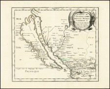
Marvelous early map of Oregon Territory, shown extending to 54 degrees, 40 minutes, and therefore claiming most of British Columbia for the United States.
This map is likely the most detailed map of the region to appear in a Commercial Atlas prior to 1850. Numerous forts are shown (MacKensie, Pitt, Hall, Bourse, Kutani, Okanagan, Vancouver, George, Umqua, Nesquatty, Kaoulis, Nes Perces and others), early settlements, Missions, a German Monestery on the Nesqually River, fur trading stations, mountains, elevations,
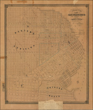
The main map extends south to Monterey, with notes on the Sierra Nevadas. Large insets of the Columbia River and San Francisco Bay. A fabulous map. The map may have been influenced by Duflot du Mofras, whose map of the Western United States appeared shortly before this map was issued.
The first example of the map we have offered in 7 years.
![[Mexico and Central America with Baja California inset, from Generalkarte von Nord America samt den Westindischen Inseln Versasst von Herrn. Pownall . . . MDCCLXXXVIII]](https://storage.googleapis.com/raremaps/img/small/95064.jpg)
![The Coast of Newfoundland From Plancentia to Cape Bonavista [and] A Draught of the River Plata in South America [and] Havana, Harbour [and] the Bay of Honda](https://storage.googleapis.com/raremaps/img/small/38599.jpg)