|
||

|

|
|

|
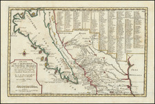
Rare thematic map of the Sacramento and Tulare Valleys by George H. Baker, one of the most important early California lithographers and illustrators.
George H. Baker acknowledged as one of early California's leading artists and lithographers whose pioneering work documented California's earliest history. The map would seem to have been prepared for a pamphlet prepared in or shortly after 1875, utilizing recently prepared information from Whitney and several other maps or the region, as described below. Our best guess is that this map may in some way relate to the series of water supply maps commissioned by the San Francisco Board of Supervisors in 1875, which were also made by Baker. These includes maps focused on the Spring Valley Reservoir, Clear Lake, Blue Lake Reservoirs, Calaveras Reservoir and a General map of the Surveys of the San Francisco Water Supply, under the direction of T.R. Allardt.
The map extend from Shasta County, Lassens Peak and Honey Lake in the north to Bakersfield, Kern Lake nad Buena Vista Lake in the south, centered on the San Francisco Bay, Tuolomne, San Joaquin and Calaveras Counties.
The map identifies the incidences and location of Malarial Fever outbreaks in the region (1858 and 1874), along with the Isothermal Lines of 1860 and 1870-1875. County Boundaries, Railroads, finished canals, surveyed canals, hypothetical irigation canals and swamp & overflowed lands are also noted. The hypothetical cachement basins are also identified, along with statistical details concerning size.
The source of the map is the Map of The San Joaquin, Sacramento And Tulare Valleys, State Of California, prepared under the direction of the Board Of Commissioners On Irrigation appointed under the Act of Congress approved March 3rd 1873, showing the country that may be irrigated and a Provisional System Of Irrigation Compiled from the Maps of the Geological Survey Of California and from Special Surveys and Examinations. 1873, which includes similar topographical details as shown in the key note, lower left, but there is no similar note regarding Malarial Fever or Isothermal Lines, suggesting that this is the purpose of Baker's map.
The map is apparently quite rare. OCLC locates only the UC Davis copy.

![[ Upper California, Texas and Mexico ] Carte Generale Du Mexique Ed Des Provinces-unies De L'Amerique Central ou Guatemala](https://storage.googleapis.com/raremaps/img/small/81604.jpg)